
IMAGES TAKEN NEAR TO
Poultney Road, COVENTRY, CV6 1JD
Introduction
This page details the photographs taken nearby to Poultney Road, CV6 1JD by members of the Geograph project.
The Geograph project started in 2005 with the aim of publishing, organising and preserving representative images for every square kilometre of Great Britain, Ireland and the Isle of Man.

There are currently over 7.5m images from over14,400 individuals and you can help contribute to the project by visiting https://www.geograph.org.uk
Image Map
Images are licensed for reuse under creativecommons.org/licenses/by-sa/2.0
Notes
- Clicking on the map will re-center to the selected point.
- The higher the marker number, the further away the image location is from the centre of the postcode.
Image Listing (46 Images Found)
Images are licensed for reuse under creativecommons.org/licenses/by-sa/2.0
Image
Details
Distance
1
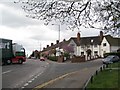
Eddie Stobart's U-turn in Engleton Road
Observed with dropped jaw from the corner of Radford Common at the junction with Holland Road.
Image: © Robin Stott
Taken: 16 Apr 2010
0.02 miles
2
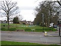
Radford Common
Coventry's commons became public open spaces by Act of Parliament in 1927. This is the southeast corner of a once much more extensive common, seen across Engleton Road at its junction with Radford Road. The level ground nearest the road was the original site of the Radford war memorial Image In the 1980s, because of increasing damage and because the ground could be muddy for the Remembrance ceremony in November, the memorial was moved to a position nearer St Nicholas Church, behind the camera Image
Image: © Robin Stott
Taken: 16 Apr 2010
0.04 miles
3
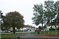
Engleton Road from Radford Common
Looking through Radford Common's new play area to Engleton Road. Note the blue awning of Godiva Chiropractic Centre in the lower left of the picture - one of many businesses across Coventry named after the legendary Lady Godiva.
Image: © Niki Walton
Taken: 12 Oct 2007
0.04 miles
4
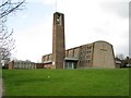
St Nicholas Church, Radford
The church was completed to "a highly original design" and consecrated in September 1955. Although somewhat altered and extended, the church has been proposed for Grade II listing by the Twentieth Century Society http://www.c20society.org.uk/ The church replaced a modest Victorian parish church, sited to the southwest, that was destroyed in an air raid in November 1940 with the loss of four lives.
Image: © Robin Stott
Taken: 16 Apr 2010
0.07 miles
5
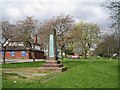
Radford War Memorial
It commemorates those from Radford who fought in the First World War and was given to the village in 1919 by Vernon Pugh. It was originally sited on the corner of Radford Common, at the junction with Engleton Road, seen in Image and in the distance, right http://www.geograph.org.uk/photo/583290 . It was moved in the 1980s at the suggestion of the British Legion, who were concerned about the damage it was incurring, and the sometimes muddy nature of the site. Thirty years on, between St Nicholas Church and the Radford Road, the memorial is no less prone to damage.
Image: © Robin Stott
Taken: 16 Apr 2010
0.07 miles
6
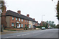
Terraced Cottages, Engleton Road
These cottages were built during WW1 by German POWs.
Image: © Niki Walton
Taken: 12 Oct 2007
0.07 miles
7
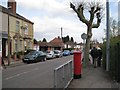
Villa Road, Radford
A plaque on the house out of shot, left, says 'Villa Road Terrace 1898'. The postbox ID is CV6 156.
Image: © Robin Stott
Taken: 16 Apr 2010
0.08 miles
8
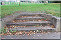
Steps, Radford Common
Three shallow steps leading from Engleton Road to Radford Common.
Image: © Niki Walton
Taken: 12 Oct 2007
0.08 miles
9
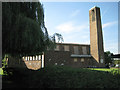
St Nicholas Church, Radford, Coventry CV6
Since Image, 2010, the windows have been boarded up.
The church was completed to "a highly original design" and consecrated in September 1955. Although somewhat altered and extended, the church has been proposed for Grade II listing by the Twentieth Century Society http://www.c20society.org.uk/ The church replaced a modest Victorian parish church, sited to the southwest, that was destroyed in an air raid in November 1940 with the loss of four lives.
Image: © Robin Stott
Taken: 9 Aug 2012
0.08 miles
10

St. Nicholas Church, Radford, Coventry
A large church building with a tall bell tower, occupying a prominent site on a slope above Radford Road and Radford Common. It is a Church of England parish church constructed in 1955-57 to designs by Lavender, Twentyman & Percy. It replaced one of 1874 that was completely destroyed in the air raid of November 1940. The church is now boarded up and the congregation worships in the adjoining church hall, visible to the left of the picture, which was built at the same time. The church building is said to be suffering from rusting of the steel reinforcement bars within the concrete, and the diocese proposes demolition. https://www.heritagegateway.org.uk/Gateway/Results_Single.aspx?uid=MCT707&resourceID=1029 https://news.coventrysociety.org.uk/2020/04/15/st-nicholas-church-radford-worthy-of-listing/
Image: © A J Paxton
Taken: 9 Jun 2021
0.09 miles