IMAGES TAKEN NEAR TO
Rye Hill, COVENTRY, CV5 9PH
Introduction
This page details the photographs taken nearby to Rye Hill, CV5 9PH by members of the Geograph project.
The Geograph project started in 2005 with the aim of publishing, organising and preserving representative images for every square kilometre of Great Britain, Ireland and the Isle of Man.

There are currently over 7.5m images from over14,400 individuals and you can help contribute to the project by visiting https://www.geograph.org.uk
Image Map
Images are licensed for reuse under creativecommons.org/licenses/by-sa/2.0
Notes
- Clicking on the map will re-center to the selected point.
- The higher the marker number, the further away the image location is from the centre of the postcode.
Image Listing (40 Images Found)
Images are licensed for reuse under creativecommons.org/licenses/by-sa/2.0
Image
Details
Distance
1
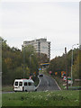
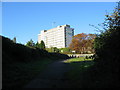
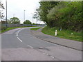
Coventry Hill Hotel, whilst waiting in a queue!
A usual queue from the A45 to head towards Coundon Wedge. The Coventry Hill Hotel is over the roundabout, with the fabulous one way only garage just visible.
Image: © Richard Harrison
Taken: 30 Oct 2005
0.00 miles
4
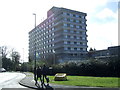
Coventry Hill Hotel
On Birmingham Road: http://www.britanniahotels.com/hotels/coventry-hill/
Image: © Mike Faherty
Taken: 7 Jun 2014
0.02 miles
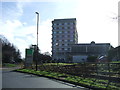
5
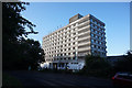
Coventry Hill Hotel, Rye Hill
The top of Park Hill Lane, now cut off, and the hotel on the other side of the A45. Park Hill Lane was the route from Eastern Green to the Windmill Hill end of Allesley until the A45 southern bypass was built and the pre-existing road between Allesley and Meriden was made dual carriageway. It continued to be open to through traffic travelling in a westerly direction until the 1970s.
Image: © E Gammie
Taken: 10 Oct 2010
0.02 miles
6
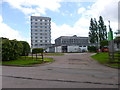
Britannia Coventry Hill Hotel
View from Birmingham Road, Allesley.
Image: © JThomas
Taken: 4 Mar 2017
0.02 miles
7
Boundary Marker by Birmingham Road, Allesley
This cast iron post marks the boundary between the city of Coventry and the parish of Allesley from 1st April 1926, when Coventry was extended westward with the purchase of land from the Stoneleigh estate, which was to become the western suburbs of the city. In 1974 Allesley, too, became part of Coventry, though it retains its own parish council.
Image: © A J Paxton
Taken: 15 Oct 2023
0.03 miles
8
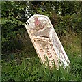
Old Boundary Marker by Birmingham Road, Coventry parish
Parish Boundary Marker by the UC road (was A45), in parish of Coventry (Coventry District), Birmingham Road, at junction with Windmill Hill, opposite hotel entrance on verge.
Inscription reads:-
: PARISH OF / ALLESLEY : : CITY OF / COVENTRY :
Surveyed
Milestone Society National ID: WA_COVAL2pb
Image: © Milestone Society
Taken: Unknown
0.04 miles
9
The City Boundary Marker on the Birmingham Road
The Boundary Marker, so eloquently and fully described in Image, at the roadside on the old Birmingham Road, Allesley. The old road has, for the most part, been subsumed by the A45 dual carriageway.
Image: © Richard Law
Taken: 14 Apr 2011
0.05 miles
10
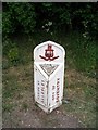
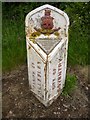
Boundary marker, Allesley
Marks the boundary between Allesley Parish and Coventry City and stands at the junction of The Windmill Hill with the Birmingham Road. The plaque reads "The boundary of the city was extended to this point April 1st 1928. Fred Lee. Mayor". The 1928 extension trebled the area of the city of Coventry from 4,147 to 12,878 acres, enveloping the village of Allesley which lies to the right of this marker. The decoration is the pre-WW2 city crest of (white!) elephant and castle surmounted by a wild cat.
Image: © E Gammie
Taken: 6 May 2007
0.05 miles