IMAGES TAKEN NEAR TO
Winsford Avenue, COVENTRY, CV5 9NH
Introduction
This page details the photographs taken nearby to Winsford Avenue, CV5 9NH by members of the Geograph project.
The Geograph project started in 2005 with the aim of publishing, organising and preserving representative images for every square kilometre of Great Britain, Ireland and the Isle of Man.

There are currently over 7.5m images from over14,400 individuals and you can help contribute to the project by visiting https://www.geograph.org.uk
Image Map (Loading...)


Getting Data...Please wait
Leaflet Map data © OpenStreetMap
Images are licensed for reuse under creativecommons.org/licenses/by-sa/2.0
Notes
- Clicking on the map will re-center to the selected point.
- The higher the marker number, the further away the image location is from the centre of the postcode.
Image Listing (76 Images Found)
Images are licensed for reuse under creativecommons.org/licenses/by-sa/2.0
Image
Details
Distance
1
St Christopher's church
The church stands at the top of Buckingham Rise at its junction with Winsford Avenue. Built in the 1950s/60s with the rest of Allesley Park estate.
Image: © E Gammie
Taken: 25 Dec 2013
0.04 miles
2
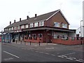
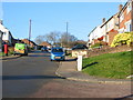
Parade of shops
These are on the corner of Winsford Avenue and Bletchley Drive.
Image: © Keith Williams
Taken: 26 Mar 2008
0.05 miles
3
St Christopher's Church, Allesley Park
Image: © Keith Williams
Taken: 26 Mar 2008
0.06 miles
4
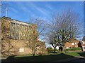
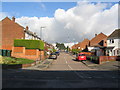
Winsford Avenue, Allesley Park
Winsford Avenue just before the drop down to the shops at the junction of Winsford Avenue and Whitaker Road. Housing is typical of the Allesley Park estate built in the 1960s. The tower blocks on the horizon are in the city centre (Image and Image).
Image: © E Gammie
Taken: 15 Nov 2007
0.07 miles
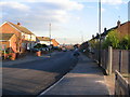
5
Buckingham Rise, Allesley Park
Looking up Buckingham Rise from the corner of Denham Avenue.
Image: © E Gammie
Taken: 25 Dec 2014
0.10 miles
6
Buckingham Rise, Allesley Park
Looking down Buckingham Rise as it drops steeply away to the brookstray and across to Whoberley. The trees on the horizon are in Hearsall Common at SP3078.
Image: © E Gammie
Taken: 3 Dec 2008
0.12 miles
7
Wendover Rise, Allesley Park
Wendover Rise seen from the junction with Winsford Avenue. The trees at the far end may be remnants of the former Allesley Hall estate landscaping.
Image: © E Gammie
Taken: 12 Nov 2013
0.12 miles
8

Top of Buckingham Rise, Allesley Park
The snow from a week before has persisted on northward facing rooftops. Sunny pavements are clear, but those in the shade still have patches of packed snow and ice. The frontage of the Minstrel Boy public house is just visible on the left.
South facing rooftops on the same day: http://www.geograph.org.uk/photo/2207824
Image: © E Gammie
Taken: 25 Dec 2010
0.13 miles
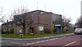
9
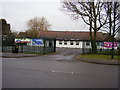
Allesley Park Community Centre
Situated on Winsford Avenue.
Image: © Anthony Vosper
Taken: 12 Feb 2010
0.14 miles
10
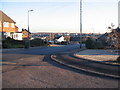
Allesley Park, Bus Terminus
The turn around point for the No.23 bus.
Situated behind although not marked on a map is Allesley Castle. A small Motte and Bailey.
Little is historically known about this site.
Image: © Anthony Vosper
Taken: 12 Feb 2010
0.15 miles