IMAGES TAKEN NEAR TO
Winsford Avenue, COVENTRY, CV5 9JF
Introduction
This page details the photographs taken nearby to Winsford Avenue, CV5 9JF by members of the Geograph project.
The Geograph project started in 2005 with the aim of publishing, organising and preserving representative images for every square kilometre of Great Britain, Ireland and the Isle of Man.

There are currently over 7.5m images from over14,400 individuals and you can help contribute to the project by visiting https://www.geograph.org.uk
Image Map (Loading...)


Getting Data...Please wait
Leaflet Map data © OpenStreetMap
Images are licensed for reuse under creativecommons.org/licenses/by-sa/2.0
Notes
- Clicking on the map will re-center to the selected point.
- The higher the marker number, the further away the image location is from the centre of the postcode.
Image Listing (74 Images Found)
Images are licensed for reuse under creativecommons.org/licenses/by-sa/2.0
Image
Details
Distance
1
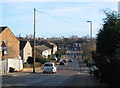
Winsford Avenue, Allesley Park
A sunny Christmas Day after days of wind and heavy rain. Looking down Winsford Avenue towards the shops and, in line with the road, the spires of Holy Trinity and St Michael's in the city centre.
Image: © E Gammie
Taken: 25 Dec 2013
0.04 miles
2
Winsford Avenue, Allesley Park
Looking down the drop to the shops at the junction of Whitaker Road and Winsford Avenue (centre). The buses have difficulties on this slope in snowy conditions. The spires of Holy Trinity and St Michaels in Image are visible on the horizon.
Image: © E Gammie
Taken: 15 Nov 2007
0.04 miles
3
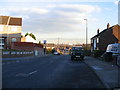
Shops, Winsford Avenue
A thriving set of shops on the corner of Winsford Avenue and Whitaker Road. However, on a Sunday it is shutter-land.
Image: © E Gammie
Taken: 5 Feb 2012
0.05 miles
4
Shops, Whitaker Road
A thriving set of shops at the corner. Bakery, opticians, suit hire, fish and chip shop, bookies.
Image: © E Gammie
Taken: 5 Feb 2012
0.07 miles
5
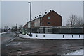
Winsford Avenue
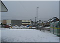
The junction of Whitaker Road (left) with Winsford Avenue after an overnight snowfall of 8-10cm. Main roads have been gritted and the bus has successfully negotiated both up and back down Winsford Avenue.
The block on the far side of Whitaker Road is phase 1 of the Allesley Park neighbourhood centre which opened in 2011. The new centre currently houses a library, replacing a mobile service, and a medical centre, moved from the block which stood at the corner and was recently demolished, hence the rubble at the corner.
A similar view in worse snow in 1990 shows the former medical centre: http://www.geograph.org.uk/photo/1073466 . Street lighting and bus stops have also altered in the intervening years.
Image: © E Gammie
Taken: 5 Feb 2012
0.08 miles
6
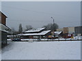
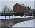
Wilfred Spencer centre, Whitaker Road
The morning after an overnight snow fall of 8-10cm and the giant snowball-makers have been at work. To the right, work continues on the new Allesley Park neighbourhood centre.
Image: © E Gammie
Taken: 5 Feb 2012
0.08 miles
7

Winsford Avenue in snow, 1990
On the morning of Saturday 8th December 1990, a heavy localised snowfall accompanied by strong winds caused chaos on the roads in the area. This photograph, taken in the afternoon, shows the junction with Whitaker Road foreground left and the bus shelter foreground right. Pedestrians are walking up the centre of Winsford Avenue.
Image: © E Gammie
Taken: 8 Dec 1990
0.10 miles

10
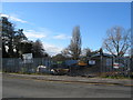
Bethesda church site
Work in progress at the Bethesda church site in Whitaker Road.
See also the first chapel, opened in 1966 : Image (2008).
The finished article : Image] (2013)
Image: © E Gammie
Taken: 25 Nov 2012
0.11 miles