IMAGES TAKEN NEAR TO
Browns Lane, COVENTRY, CV5 9EF
Introduction
This page details the photographs taken nearby to Browns Lane, CV5 9EF by members of the Geograph project.
The Geograph project started in 2005 with the aim of publishing, organising and preserving representative images for every square kilometre of Great Britain, Ireland and the Isle of Man.

There are currently over 7.5m images from over14,400 individuals and you can help contribute to the project by visiting https://www.geograph.org.uk
Image Map
Images are licensed for reuse under creativecommons.org/licenses/by-sa/2.0
Notes
- Clicking on the map will re-center to the selected point.
- The higher the marker number, the further away the image location is from the centre of the postcode.
Image Listing (4 Images Found)
Images are licensed for reuse under creativecommons.org/licenses/by-sa/2.0
Image
Details
Distance
1
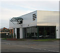
Jaguar's Heritage Centre, Coventry
The small heritage centre at the back of the Brown's Lane works...only open by appointment, relive the glory days of Jag in Cov!
Image: © Richard Harrison
Taken: 28 Oct 2005
0.14 miles
2
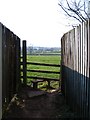
Stile at Browns Lane
The transition from suburb to rural is at the end of an entry on Browns Lane. This stile leads to the footpath across fields to Hawkes End.
Image: © E Gammie
Taken: 1 Apr 2007
0.17 miles
3
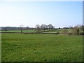
Fields near Browns Lane
Looking NW across farmland from the Browns Lane end of the footpath from Hawkes Mill Lane.
Image: © E Gammie
Taken: 1 Apr 2007
0.22 miles
4
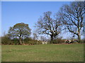
Field near Hawkes End
Looking towards the gate on the footpath between Hawkes Mill Lane and Browns Lane. Metal gates have replaced many of the wooden stiles round here. Sheep with lambs are in the field beyond.
Image: © E Gammie
Taken: 1 Apr 2007
0.24 miles