IMAGES TAKEN NEAR TO
Holyhead Road, COVENTRY, CV5 8LD
Introduction
This page details the photographs taken nearby to Holyhead Road, CV5 8LD by members of the Geograph project.
The Geograph project started in 2005 with the aim of publishing, organising and preserving representative images for every square kilometre of Great Britain, Ireland and the Isle of Man.

There are currently over 7.5m images from over14,400 individuals and you can help contribute to the project by visiting https://www.geograph.org.uk
Image Map
Images are licensed for reuse under creativecommons.org/licenses/by-sa/2.0
Notes
- Clicking on the map will re-center to the selected point.
- The higher the marker number, the further away the image location is from the centre of the postcode.
Image Listing (22 Images Found)
Images are licensed for reuse under creativecommons.org/licenses/by-sa/2.0
Image
Details
Distance
1
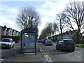
Bus stop and shelter on Holyhead Road, Coventry
Image: © JThomas
Taken: 4 Mar 2017
0.02 miles
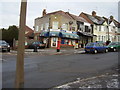
2
Holyhead Fish Saloon
Junction of Redesdale Avenue and Holyhead Road.
Image: © Anthony Vosper
Taken: 11 Feb 2010
0.02 miles
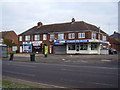
5
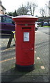
Elizabeth II postbox on Holyhead Road
Postbox No. CV6 11.
See Image] for context.
Image: © JThomas
Taken: 4 Mar 2017
0.16 miles
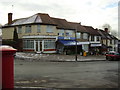
6
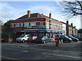
Shops on Holyhead Road
Showing position of Postbox No. CV6 11.
See Image] for postbox.
Image: © JThomas
Taken: 4 Mar 2017
0.16 miles
7
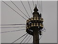
Before we 'all' had mobile phones
Lake View Road.
A decorative telegraph pole complete with cable insulators.
The lake however was never constructed due to the outbreak of WWII.
Image: © Anthony Vosper
Taken: 7 Jun 2014
0.16 miles
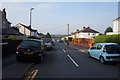
8
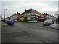
Southbank Road and Lavender Avenue, North East
Once a busy crossroads with thriving shops on each corner.
The Ice Cream van may be a clue as to what the owners of the shops now do.
Image: © Anthony Vosper
Taken: 11 Feb 2010
0.19 miles
9
Southbank Road and Lavender Avenue, South East
Once a busy crossroads with thriving shops on each corner.
All now showing signs of urban decay.
Image: © Anthony Vosper
Taken: 11 Feb 2010
0.19 miles
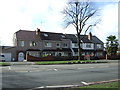
10
Southbank Road and Byfield Road, North West
Once a busy crossroads with thriving shops on each corner.
This was once the Post office.
Image: © Anthony Vosper
Taken: 11 Feb 2010
0.21 miles