IMAGES TAKEN NEAR TO
Oldfield Road, COVENTRY, CV5 8FR
Introduction
This page details the photographs taken nearby to Oldfield Road, CV5 8FR by members of the Geograph project.
The Geograph project started in 2005 with the aim of publishing, organising and preserving representative images for every square kilometre of Great Britain, Ireland and the Isle of Man.

There are currently over 7.5m images from over14,400 individuals and you can help contribute to the project by visiting https://www.geograph.org.uk
Image Map
Images are licensed for reuse under creativecommons.org/licenses/by-sa/2.0
Notes
- Clicking on the map will re-center to the selected point.
- The higher the marker number, the further away the image location is from the centre of the postcode.
Image Listing (24 Images Found)
Images are licensed for reuse under creativecommons.org/licenses/by-sa/2.0
Image
Details
Distance
2
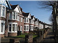
Allesley Old Road
A beautiful row of immaculate terraced 1930's housing on the north side of this treelined dual carriageway in Chapel Fields
Image: © Nigel Mykura
Taken: 11 Feb 2012
0.14 miles
3
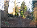
Urban bridleway
The bottom part of the public bridleway which runs parallel to Glendower Avenue near its exit onto Allesley Old Road.
See also Image] (2007).
Image: © E Gammie
Taken: 1 Dec 2016
0.15 miles
4
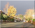
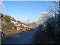
Glendower Avenue, Whoberley
Looking down Glendower Avenue towards the Scots pines at the junction with Brookside Avenue. An afternoon of bright sunshine between heavy rain showers.
Image: © E Gammie
Taken: 23 Nov 2008
0.16 miles
5
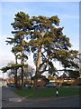
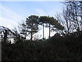
Brookside and Glendower
These Scots pines stand at the junction of Glendower Avenue and Brookside Avenue and are probably survivors from the old Whoberley Hall estate.
One tree less, 2013: http://www.geograph.org.uk/photo/3515767
Image: © E Gammie
Taken: 27 Jan 2008
0.17 miles
6
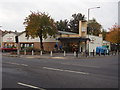
The local Co-op
A post war development situated at the junction of the Allesley Old Road and Glendower Avenue.
Image: © Anthony Vosper
Taken: 27 Oct 2009
0.17 miles
7
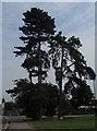
Brookside and Glendower
The Scots pines at the junction of Glendower and Brookside Avenues seem to have lost one of their number since 2008 ( Image] ).
Image: © E Gammie
Taken: 18 Jun 2013
0.17 miles
8
Glendower Avenue, Whoberley
Houses at the lower end of Glendower Avenue constructed in the 1950s.
Image: © E Gammie
Taken: 7 Dec 2010
0.18 miles
9
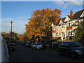
Glendower Avenue
Maples showing autumn colour in Glendower Avenue. The houses in the foreground are in a short terrace of bay windowed properties typical of many built in Coventry suburbs in the late 1920s to 1930s.
Image: © E Gammie
Taken: 28 Oct 2015
0.18 miles
10
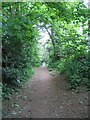
Urban bridleway
This public bridleway runs parallel to Glendower Avenue between the corner of Guphill Avenue and Allesley Old Road. It is shown on the 1889 OS map as Guphill Lane and ran from Whoberley Lane (now Guphill Avenue) to join what was then called the Old Allesley Road at Guphill Ford Bridge. It was on the western boundary of the city between the boundary changes of 1842 and 1928.
Image: © E Gammie
Taken: 4 May 2007
0.19 miles