IMAGES TAKEN NEAR TO
Allesley Old Road, COVENTRY, CV5 8FP
Introduction
This page details the photographs taken nearby to Allesley Old Road, CV5 8FP by members of the Geograph project.
The Geograph project started in 2005 with the aim of publishing, organising and preserving representative images for every square kilometre of Great Britain, Ireland and the Isle of Man.

There are currently over 7.5m images from over14,400 individuals and you can help contribute to the project by visiting https://www.geograph.org.uk
Image Map (Loading...)


Getting Data...Please wait
Leaflet Map data © OpenStreetMap
Images are licensed for reuse under creativecommons.org/licenses/by-sa/2.0
Notes
- Clicking on the map will re-center to the selected point.
- The higher the marker number, the further away the image location is from the centre of the postcode.
Image Listing (26 Images Found)
Images are licensed for reuse under creativecommons.org/licenses/by-sa/2.0
Image
Details
Distance
1
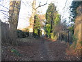
Urban bridleway
The bottom part of the public bridleway which runs parallel to Glendower Avenue near its exit onto Allesley Old Road.
See also Image] (2007).
Image: © E Gammie
Taken: 1 Dec 2016
0.10 miles
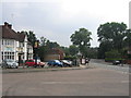
2
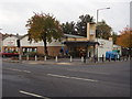
The local Co-op
A post war development situated at the junction of the Allesley Old Road and Glendower Avenue.
Image: © Anthony Vosper
Taken: 27 Oct 2009
0.13 miles
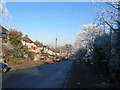
3
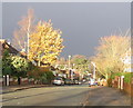
Glendower Avenue, Whoberley
Looking down Glendower Avenue towards the Scots pines at the junction with Brookside Avenue. An afternoon of bright sunshine between heavy rain showers.
Image: © E Gammie
Taken: 23 Nov 2008
0.14 miles
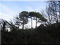
4
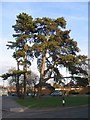
Brookside and Glendower
These Scots pines stand at the junction of Glendower Avenue and Brookside Avenue and are probably survivors from the old Whoberley Hall estate.
One tree less, 2013: http://www.geograph.org.uk/photo/3515767
Image: © E Gammie
Taken: 27 Jan 2008
0.14 miles
5
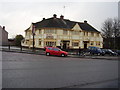
The New Spires
Grayswood Avenue.A fresh coat of paint and a new name.
Formerly The Three Spires, The Jules Verne 70's theme pub, and The Spires.
This was one of many local pubs with a bowling green sadly all have been given over to parking.
Image: © Anthony Vosper
Taken: 12 Feb 2010
0.14 miles
6
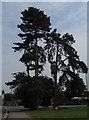
Brookside and Glendower
The Scots pines at the junction of Glendower and Brookside Avenues seem to have lost one of their number since 2008 ( Image] ).
Image: © E Gammie
Taken: 18 Jun 2013
0.14 miles
7
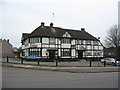
The New Spires, Grayswood Avenue
The 1930s-built public house has had another colour transformation back to black and white since its brief foray into pastel shades. Opened as the Three Spires Hotel, it became the Jules Verne theme pub in the early 1970s then the Spires Tavern, the Rectory by the late 1980s and now the New Spires with a 'pub for let' sign on its frontage to the right of the bay windows.
2005: http://www.geograph.org.uk/photo/30033
In its custard period, 2010: http://www.geograph.org.uk/photo/1706330
Image: © E Gammie
Taken: 9 Feb 2012
0.14 miles
8
Grayswood Avenue, Coventry
This is an area of 1930s housing development. The view here is looking towards the junction with the Allesley Old Road.
Image: © David Stowell
Taken: 23 Jul 2005
0.14 miles
10
Glendower Avenue, Whoberley
Houses at the lower end of Glendower Avenue constructed in the 1950s.
Image: © E Gammie
Taken: 7 Dec 2010
0.16 miles