IMAGES TAKEN NEAR TO
Allesley Old Road, COVENTRY, CV5 8FJ
Introduction
This page details the photographs taken nearby to Allesley Old Road, CV5 8FJ by members of the Geograph project.
The Geograph project started in 2005 with the aim of publishing, organising and preserving representative images for every square kilometre of Great Britain, Ireland and the Isle of Man.

There are currently over 7.5m images from over14,400 individuals and you can help contribute to the project by visiting https://www.geograph.org.uk
Image Map
Images are licensed for reuse under creativecommons.org/licenses/by-sa/2.0
Notes
- Clicking on the map will re-center to the selected point.
- The higher the marker number, the further away the image location is from the centre of the postcode.
Image Listing (121 Images Found)
Images are licensed for reuse under creativecommons.org/licenses/by-sa/2.0
Image
Details
Distance
1
Allesley Old Road, Chapelfields, Coventry
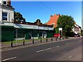
Allesley Old Road, looking towards the junction with Four Pounds Avenue and Queensland Road. Until the 1920s this was on the western fringe of the city, with a handful of houses along the road beyond the watchmaking district of Chapelfields. The rendered 19th century house at the far right of the picture bears a plaque erected by the Coventry Watch Museum Project, indicating that this was Cambrian House, site of the watchmakers W H Adams and Son from 1889 to 1953. In the 1920s and 1930s this stretch of the road and the fields behind were filled with housing, shop units and the occasional roadside pub like the Maudslay, not visible here. A single-storey shop unit dated 1929 on the parapet, formerly Enchanted Interiors, now houses the Iqra Learning Centre, a mosque.
Image: © A J Paxton
Taken: 12 Jun 2021
0.02 miles
2
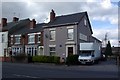
164 Allesley Old Road
A former watch making premises, identified by the Coventry Watch Museum Project plaque, shown here Image
This is the 15th site on the Coventry Watchmakers' Heritage Trail.
The 16th site is at 51 Allesley Old Road, Image, which is currently being redeveloped, and not displaying a plaque.
The 17th site on the trail is Image
The prior site on the trail is Image
Image: © Keith Williams
Taken: 4 Apr 2009
0.02 miles
3
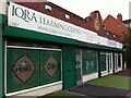
Storefront mosque on Allesley Old Road
A single-storey commercial building on a main road out of Coventry, dated 1929 on the parapet, and now in use as a mosque and madrassah (Islamic school).
Image: © A J Paxton
Taken: 2 Sep 2018
0.02 miles
4
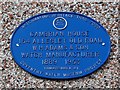
Coventry Watch Museum Project plaque on 164 Allesley Old Road
Image: © Keith Williams
Taken: 4 Apr 2009
0.02 miles
7
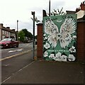
Love where you live: Queensland Avenue, Whoberley
"Love where you live, stop littering." The mural advertises the neighbouring flower shop and shares its colour scheme. The artist is Katie Sullivan of Katie-O-Art.
Image: © A J Paxton
Taken: 29 Jul 2022
0.05 miles
8
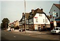
The Maudslay
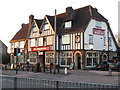
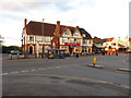
A 'roadhouse' style public house constructed in the 1920s/30s, as was most of the housing nearby. It stands on Allesley Old Road opposite the bottom of Maudslay Road where the Maudslay Motor Co. had a works in the 1920s-30s. At the time of this photo the pub was an M&B (Mitchells and Butlers) establishment.
To the right, the National Petroleum sign is on the forecourt of the Old Road Garage, later to be replaced by a monumental mason's business.
In 2009 : http://www.geograph.org.uk/photo/1236779
Image: © FCG
Taken: Unknown
0.06 miles