IMAGES TAKEN NEAR TO
Suffolk Close, COVENTRY, CV5 7JB
Introduction
This page details the photographs taken nearby to Suffolk Close, CV5 7JB by members of the Geograph project.
The Geograph project started in 2005 with the aim of publishing, organising and preserving representative images for every square kilometre of Great Britain, Ireland and the Isle of Man.

There are currently over 7.5m images from over14,400 individuals and you can help contribute to the project by visiting https://www.geograph.org.uk
Image Map
Images are licensed for reuse under creativecommons.org/licenses/by-sa/2.0
Notes
- Clicking on the map will re-center to the selected point.
- The higher the marker number, the further away the image location is from the centre of the postcode.
Image Listing (81 Images Found)
Images are licensed for reuse under creativecommons.org/licenses/by-sa/2.0
Image
Details
Distance
1
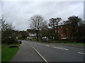
Nod Rise, Mount Nod
Flats and houses on a 1950s/1960s estate, near the bridge over the brook.
Image: © E Gammie
Taken: 29 Nov 2015
0.10 miles
2
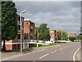
Lower Eastern Green, Coventry
These blocks of flats on Nod Rise are well maintained and sit in nicely tended grounds making up for their rather bland and rectangular design.
Image: © David Stowell
Taken: 29 Aug 2005
0.10 miles
3
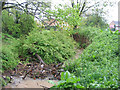
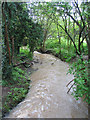
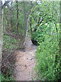
Brook, Mount Nod
Partially blocked by accumulated small branch debris after heavy rain and strong wind. Further along, the stream has undercut the right bank. Brookstray Flats in the background, centre and houses on Nod Rise, right.
Image: © E Gammie
Taken: 29 Apr 2012
0.11 miles
4
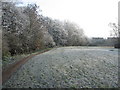
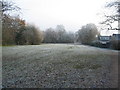
Brookstray, Mount Nod
A narrow strip of green runs alongside the brook behind Nod Rise. A mixed day of heavy frost, fog and bright sunlight.
Image: © E Gammie
Taken: 6 Dec 2010
0.11 miles
5
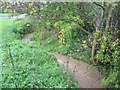
Brook below the outfall, Mount Nod
After heavy rain
Image: © E Gammie
Taken: 29 Apr 2012
0.11 miles
6
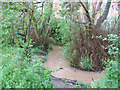
Meandering brook, Mount Nod
After heavy rain. Flats in Nod Rise in the background.
Image: © E Gammie
Taken: 29 Apr 2012
0.11 miles
7
Brookstray, Mount Nod
Closes off Mount Nod Way end at the green alongside the brook.
Image: © E Gammie
Taken: 6 Dec 2010
0.11 miles
9
The brook from Nod Rise bridge
After heavy rain.
Image: © E Gammie
Taken: 29 Apr 2012
0.12 miles
10
The brook near Nod Rise bridge
After heavy rain.
Image: © E Gammie
Taken: 29 Apr 2012
0.12 miles