IMAGES TAKEN NEAR TO
Essex Close, COVENTRY, CV5 7HX
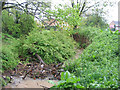
Introduction
This page details the photographs taken nearby to Essex Close, CV5 7HX by members of the Geograph project.
The Geograph project started in 2005 with the aim of publishing, organising and preserving representative images for every square kilometre of Great Britain, Ireland and the Isle of Man.

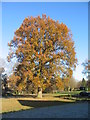
There are currently over 7.5m images from over14,400 individuals and you can help contribute to the project by visiting https://www.geograph.org.uk
Image Map (Loading...)


Getting Data...Please wait
Leaflet Map data © OpenStreetMap
Images are licensed for reuse under creativecommons.org/licenses/by-sa/2.0
Notes
- Clicking on the map will re-center to the selected point.
- The higher the marker number, the further away the image location is from the centre of the postcode.
Image Listing (118 Images Found)
Images are licensed for reuse under creativecommons.org/licenses/by-sa/2.0
Image
Details
Distance
1
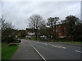
Nod Rise, Mount Nod
Flats and houses on a 1950s/1960s estate, near the bridge over the brook.
Image: © E Gammie
Taken: 29 Nov 2015
0.03 miles
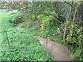
2
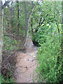
The brook from Nod Rise bridge
After heavy rain.
Image: © E Gammie
Taken: 29 Apr 2012
0.04 miles
3
The bottom of Nod Rise
Nod Rise crosses the brook via the bridge on the left. Brookstray Flats on the right.
Image: © E Gammie
Taken: 29 Nov 2016
0.05 miles
4
The brook near Nod Rise bridge
After heavy rain.
Image: © E Gammie
Taken: 29 Apr 2012
0.06 miles
5
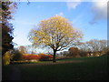
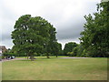
The brookstray, Lower Eastern Green
Tree catching late November afternoon light in the brookstray. The brook is to the left and the embankment shows the line of the A45 Dunchurch Highway behind the tree. The subway under the A45 is just out of sight on the left (http://www.geograph.org.uk/photo/623522 ).
Image: © E Gammie
Taken: 29 Nov 2007
0.06 miles
6
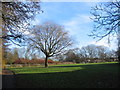
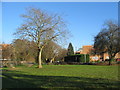
Eastern Green brookstray
A green space near Nod Rise. The brook runs to the left and the shrubs and trees in the background mask the A45.
Image: © E Gammie
Taken: 25 Dec 2013
0.06 miles
7
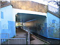
Subway under the A45
Enticing, isn't it? In its defence, you can see straight through to the other end, unlike other subways in Coventry.
Venture inside: http://www.geograph.org.uk/photo/365626
Image: © E Gammie
Taken: 29 Nov 2007
0.08 miles
8
Brook, Mount Nod
Partially blocked by accumulated small branch debris after heavy rain and strong wind. Further along, the stream has undercut the right bank. Brookstray Flats in the background, centre and houses on Nod Rise, right.
Image: © E Gammie
Taken: 29 Apr 2012
0.08 miles
9
Oaks near Nod Rise
The brookstray green space runs westward behind Nod Rise. Honeybourne Close on the left.
Image: © E Gammie
Taken: 7 Jun 2011
0.08 miles