IMAGES TAKEN NEAR TO
Frederick Neal Avenue, COVENTRY, CV5 7EH
Introduction
This page details the photographs taken nearby to Frederick Neal Avenue, CV5 7EH by members of the Geograph project.
The Geograph project started in 2005 with the aim of publishing, organising and preserving representative images for every square kilometre of Great Britain, Ireland and the Isle of Man.

There are currently over 7.5m images from over14,400 individuals and you can help contribute to the project by visiting https://www.geograph.org.uk
Image Map
Images are licensed for reuse under creativecommons.org/licenses/by-sa/2.0
Notes
- Clicking on the map will re-center to the selected point.
- The higher the marker number, the further away the image location is from the centre of the postcode.
Image Listing (9 Images Found)
Images are licensed for reuse under creativecommons.org/licenses/by-sa/2.0
Image
Details
Distance
1
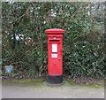
Elizabeth II postbox on Upper Eastern Green Lane, Upper Eastern Green
Postbox No. CV5 373.
See Image] for context.
Image: © JThomas
Taken: 11 Mar 2017
0.15 miles
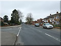
3
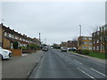
Upper Eastern Green Lane
Looking north west.
Image: © JThomas
Taken: 11 Mar 2017
0.20 miles
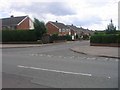
6
The junction of Broad Land and Banner Lane
Image: © Keith Williams
Taken: 9 Jun 2008
0.24 miles
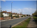
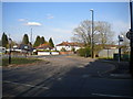
7
Upper Eastern Green Lane
Looking north west at the junction with Sutton Avenue.
Image: © JThomas
Taken: 11 Mar 2017
0.24 miles
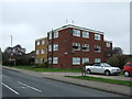
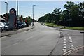
8
Bus turning circle, Eastern Green
This large turning circle, built into the junction of Banner Lane (foreground) and Broad Lane, used to have something of an identity crisis. Buses terminating here used to show one of two destinations, depending on how they got here: Eastern Green if they approached via Upper Eastern Green and Hockley Lane, or Broad Lane if they arrived via Broad Lane westbound. To confuse things further, the bus stop itself bore the name "Banner Lane Terminus". The only route terminating here currently, the 10, serves Upper Eastern Green and arrives via Broad Lane westbound, and shows Eastern Green.
Image: © Richard Vince
Taken: 2 Apr 2016
0.24 miles
9
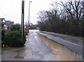
Broad Lane and Banner Lane junction flooded
After heavy overnight and morning rain. The drainage at this point is unable to cope with the combined flow of the surface water and the stream, behind the raised kerb, which flows under the road at the corner. Some traffic has passed through, although bus services have been diverted (the terminus is at the corner).
The local Bablake weather station reported 28.8mm of rainfall for 13th December 2008 midnight to midnight 24 hour period.
Image: © E Gammie
Taken: 13 Dec 2008
0.25 miles