IMAGES TAKEN NEAR TO
Stanway Road, COVENTRY, CV5 6PH
Introduction
This page details the photographs taken nearby to Stanway Road, CV5 6PH by members of the Geograph project.
The Geograph project started in 2005 with the aim of publishing, organising and preserving representative images for every square kilometre of Great Britain, Ireland and the Isle of Man.

There are currently over 7.5m images from over14,400 individuals and you can help contribute to the project by visiting https://www.geograph.org.uk
Image Map
Images are licensed for reuse under creativecommons.org/licenses/by-sa/2.0
Notes
- Clicking on the map will re-center to the selected point.
- The higher the marker number, the further away the image location is from the centre of the postcode.
Image Listing (116 Images Found)
Images are licensed for reuse under creativecommons.org/licenses/by-sa/2.0
Image
Details
Distance
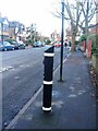
1
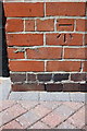
Benchmark on #28 Earlsdon Avenue South
Ordnance Survey cut mark benchmark described on the Bench Mark Database at http://www.bench-marks.org.uk/bm75414
Image: © Roger Templeman
Taken: 3 May 2016
0.07 miles
2
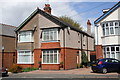
Semi-detached houses on Earlsdon Avenue South
There is an OS benchmark Image on the near corner, right hand face, of the pair of houses in the left half of the image
Image: © Roger Templeman
Taken: 3 May 2016
0.07 miles
3
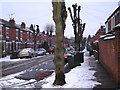
Pollarded limes, Mayfield Road
Common Lime (Tilia x europaea, a natural hybrid) grows to an impressive size, for example in parkland, but planted in small-scale spaces such as residential streets – probably with the best of intentions – it spells trouble. Coventry City has grasped the nettle and operates a programme of pollarding in order to reduce justified complaints about loss of light, falling twigs and leaves, goo on cars and potential scary height.
Image: © Robin Stott
Taken: 14 Jan 2010
0.07 miles
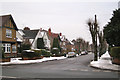
5
Earlsdon Avenue South
A kerbside electric vehicle charging point. A second one is further up the road, hidden by the tree at the pavement edge.
Image: © E Gammie
Taken: 22 Feb 2021
0.09 miles
6
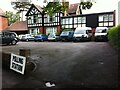
Boston Lodge
Boston Lodge on Earlsdon Avenue South, in use as a polling station for the 2017 General Election. The polling station was in a single-storey building at the rear of the back garden. Boston Lodge was a home for blind people for many years. By 2017 it was lived in by property guardians, although the extension to the left with the low sweeping roof was still in use as a resource centre for blind and partially-sighted people, run by CRCB, the Coventry Resource Centre for the Blind. In 2018 CRCB bought the entire building. http://www.coventryblind.org.uk/news/its-official-crcb-has-bought-boston-lodge
Image: © A J Paxton
Taken: 8 Jun 2017
0.09 miles
7
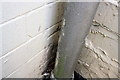
Benchmark on #27 Mayfield Road
Ordnance Survey cut mark benchmark described on the Bench Mark Database at http://www.bench-marks.org.uk/bm75418
Image: © Roger Templeman
Taken: 3 May 2016
0.10 miles
8
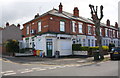
Houses and wine shop at Mayfield Road / Huntingdon Road junction
There is an OS benchmark Image tucked away on the wall of the shop where the hedge-topped wall abuts.
Image: © Roger Templeman
Taken: 3 May 2016
0.10 miles
10
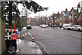
Earlsdon Avenue South
From the corner of Warwick Avenue. Postbox ID: CV5 151.
Image: © Robin Stott
Taken: 14 Jan 2010
0.13 miles