IMAGES TAKEN NEAR TO
Winifred Avenue, COVENTRY, CV5 6JS
Introduction
This page details the photographs taken nearby to Winifred Avenue, CV5 6JS by members of the Geograph project.
The Geograph project started in 2005 with the aim of publishing, organising and preserving representative images for every square kilometre of Great Britain, Ireland and the Isle of Man.

There are currently over 7.5m images from over14,400 individuals and you can help contribute to the project by visiting https://www.geograph.org.uk
Image Map
Images are licensed for reuse under creativecommons.org/licenses/by-sa/2.0
Notes
- Clicking on the map will re-center to the selected point.
- The higher the marker number, the further away the image location is from the centre of the postcode.
Image Listing (108 Images Found)
Images are licensed for reuse under creativecommons.org/licenses/by-sa/2.0
Image
Details
Distance
1

Footpath to Albany Road, Spencer Park
The footpath runs alongside the Coventry to Birmingham railway line and joins Albany Road at the exit of the park by the railway bridge. Some rail infrastructure can be glimpsed on the right but not so clearly as in a similar 1980s photo: Image]
Image: © E Gammie
Taken: 27 Oct 2022
0.04 miles
2

Footpath and railway, Spencer Park ca. 1983
A train approaching Coventry station on the Birmingham to Coventry line. Houses on Albany Road can be glimpsed below the tree on the left.
Image: © FEG
Taken: Unknown
0.05 miles
3

Autumn in Spencer Park
A row of what appear to be maples line the path alongside the Coventry to Birmingham railway at the northern edge of the park. Spencer Park was opened in 1883 and is named for a local ribbon manufacturer, David Spencer, who donated money to secure its creation.
Image: © E Gammie
Taken: 27 Oct 2022
0.06 miles
5
Spencer Avenue
Mainly early 20th Century housing, some first shown on the 1914 25 inch map.
Image: © Ian Capper
Taken: 25 Sep 2021
0.07 miles
6
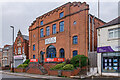
Astoria House
Built in 1922 as the Broadway Cinema, it was renamed the Astoria in the 1930s. It closed in 1959 and the building now houses the Nexus Institute of Creative Arts, a Christian music college.
Image: © Ian Capper
Taken: 25 Sep 2021
0.07 miles
7

Former Co-op, Albany Road
The entwined CCS letters carved in the arched window framework indicate that this was once a Coventry Co-operative Society building with a date stone of 1915 above the window. Some change has taken place with current occupants since A J Paxton's Image] was taken in June 2021 - the pregnancy scan service seems to have been moved to a side entrance.
Image: © E Gammie
Taken: 27 Oct 2022
0.08 miles
8
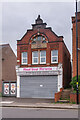
69 Albany Road
Former shop built by the Coventry Co-operative Society (hence the initials CCS below the arched window) in 1915 (the date in the gable). The building is now used by a pregnancy scan business.
Image: © Ian Capper
Taken: 25 Sep 2021
0.08 miles
9
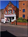
Meet your Miracle in the Co-op
The Meet your Miracle pregnancy scan studio on Albany Road, Coventry, occupies a building erected by the Coventry Co-operative Society in AD 1915, according to the carving on the stepped gable. The entwined CCS symbol of the society can be seen further down the facade, in a panel set into the round-arched window. The larger building to the right is a former cinema built seven years later.
Image: © A J Paxton
Taken: 12 Jun 2021
0.08 miles
10
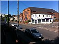
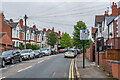
Albany Road, Coventry
Albany Road was built in 1898 and named after the Duchess of Albany, who visited Coventry that year. The lower part, seen here, followed the route of the Earlsdon Jetty, a muddy and sometimes insanitary path that had connected Earlsdon to the Butts and Coventry. Buildings soon followed and also a tram service, which lasted until the second world war. http://www.earlsdon.org.uk/history/streets/albanyrd.html
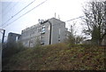
The photo is taken from the top of the steps on the path, by the upper of the two railway bridges, which leads to Westwood Road. Winifred Avenue can be seen leading off to the right. The large brick building behind the white property on the corner is the Nexus music academy. It was built in 1922 as the Broadway cinema and later renamed the Astoria before closing in 1959. http://cinematreasures.org/theaters/37913 The modern white block in the distance on the left is the Earlsdon Village development of retirement homes.
Image: © A J Paxton
Taken: 12 Jun 2021
0.08 miles