IMAGES TAKEN NEAR TO
Boar Croft, COVENTRY, CV4 9SJ
Introduction
This page details the photographs taken nearby to Boar Croft, CV4 9SJ by members of the Geograph project.
The Geograph project started in 2005 with the aim of publishing, organising and preserving representative images for every square kilometre of Great Britain, Ireland and the Isle of Man.

There are currently over 7.5m images from over14,400 individuals and you can help contribute to the project by visiting https://www.geograph.org.uk
Image Map
Images are licensed for reuse under creativecommons.org/licenses/by-sa/2.0
Notes
- Clicking on the map will re-center to the selected point.
- The higher the marker number, the further away the image location is from the centre of the postcode.
Image Listing (45 Images Found)
Images are licensed for reuse under creativecommons.org/licenses/by-sa/2.0
Image
Details
Distance
1

Closed social club, Tile Hill
Following the trend for public house and social club closures, the Tile Hill Social Club on Jardine Crescent looks pretty forlorn.
Architect: K R B McKnight. Builder: A G Gale Ltd. Built: 1962/66.
Image: © E Gammie
Taken: 23 Aug 2010
0.09 miles
2
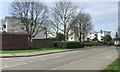
Three four-storey blocks of flats, Tile Hill North, western Coventry
The view is across Jardine Crescent. The flats appear to lack any vehicular access. Satellite photos show an on-road parking lane that clearly is not there now. Out of shot left is a construction site where the Tile Hill Social Club was: see Image, photographed in 2010. Out of shot right is the postwar St Oswald's Church: Image and related images.
Before World War II this area was fields, perhaps belonging to Tilehill Farm on Hawthorn Lane, bounded to the east by a wood called North Waste. In the early 1950s maps show a network of roads lined with small square dwellings on small plots – presumed to be prefabs. The crescent was then Humphrey Wanley Crescent. The flats pictured first appear on a map of 1960; there was a court of lock-up garages off James Green Road but this is now houses. The crescent has become Jardine Crescent.
Image: © Robin Stott
Taken: 11 Apr 2017
0.11 miles
3
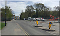
Contractors' vehicles on the site of Tile Hill Social Club, Jardine Crescent, Coventry
Compare E Gammie's view of 2010: Image Google Streetview shows that the Social Club had been demolished by 2012 and the site left vacant. Ahead is the Jardine Shopping Centre opposite Limbrick Wood, named as North Waste on a map of 1937.
Image: © Robin Stott
Taken: 11 Apr 2017
0.11 miles
4

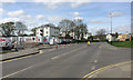
Jardine Crescent, Tile Hill
Tile Hill estate was a corporation estate built in the 1950s on the principle of a neighbourhood unit in that it should incorporate housing with facilities such as community centre, shops, primary school, public houses and churches. Unlike estates built previously it was built with a mix of housing stock to provide for a variety of family sizes, young and old. People were moved here from several different parts of the city. The existing small woodland areas were retained and one of these, Limbrick Wood, can be seen on the right standing opposite the local shopping parade.
Jardine Crescent was named after Dan Jardine, a site foreman who worked on the development. Interestingly, 1:10,560 OS maps published in 1955 show the road named as Humphrey Wanley Crescent but the official street map of Coventry published by the city of Coventry in December 1954 shows it named as Jardine Crescent. 'Humfrey' Wanley was a 17th century Coventrian who, through personal study of ancient documents and handwriting, moved on from being an apprentice draper to work with the Bodleian Library, Oxford.
Image: © E Gammie
Taken: 23 Aug 2010
0.12 miles
5
West on Jardine Crescent, Tile Hill North, western Coventry
On the left is the building site in Image and beyond it in Image On the right is the recent Image Out of shot right is Image
Image: © Robin Stott
Taken: 11 Apr 2017
0.12 miles
6
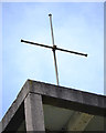
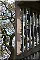
St Oswald's Church, Jardine Crescent, Tile Hill, west Coventry ? cross on the bell tower
Image: © Robin Stott
Taken: 11 Apr 2017
0.13 miles
7
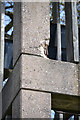
Bell tower of St Oswald's Church, Tile Hill, west Coventry ? corner concrete detail
A view of the bell tower is Image The reinforced concrete is deteriorating in several places.
Image: © Robin Stott
Taken: 11 Apr 2017
0.13 miles
8
Bell tower of St Oswald's Church, Tile Hill, west Coventry ? exposed reinforcement
A view of the bell tower is Image The reinforced concrete is deteriorating in several places.
Image: © Robin Stott
Taken: 11 Apr 2017
0.13 miles
9
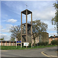
Bell tower of St Oswald's Church, Jardine Crescent, Tile Hill, west Coventry
Image: © Robin Stott
Taken: 11 Apr 2017
0.13 miles
10

Tile Hill Library
An interesting looking building on Jardine Crescent. Opened 2008.
Image: © E Gammie
Taken: 23 Aug 2010
0.13 miles