IMAGES TAKEN NEAR TO
Treedale Close, COVENTRY, CV4 9HQ
Introduction
This page details the photographs taken nearby to Treedale Close, CV4 9HQ by members of the Geograph project.
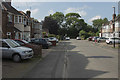
The Geograph project started in 2005 with the aim of publishing, organising and preserving representative images for every square kilometre of Great Britain, Ireland and the Isle of Man.

There are currently over 7.5m images from over14,400 individuals and you can help contribute to the project by visiting https://www.geograph.org.uk
Image Map
Images are licensed for reuse under creativecommons.org/licenses/by-sa/2.0
Notes
- Clicking on the map will re-center to the selected point.
- The higher the marker number, the further away the image location is from the centre of the postcode.
Image Listing (27 Images Found)
Images are licensed for reuse under creativecommons.org/licenses/by-sa/2.0
Image
Details
Distance
1
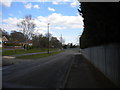
West end of Torrington Avenue, Tile Hill
Seen from near the junction with Trevor Close (left). The south side of Torrington Avenue is industrial, hence the stern metal fencing on the right.
Image: © Richard Vince
Taken: 2 Apr 2016
0.08 miles
2
Trevor Close, Tile Hill
Off Torrington Avenue.
Image: © Richard Vince
Taken: 2 Apr 2016
0.08 miles
3
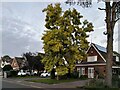
Station Avenue, Tile Hill
Tile Hill is not all council estate; it has a middle-class, ribbon-development side, suburban houses built along old lanes. The tree that is turning an autumnal deep yellow is false acacia, Robinia pseudoacacia, native to the Appalachians and parts of the Mississippi basin.
Image: © A J Paxton
Taken: 7 Oct 2023
0.09 miles
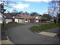
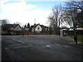
4
Hathaway Rd
This small dead end residential road consists mainly of mid 20th C semi detached houses. It is just off Tile Hill Lane close to the junction with Banner Lane, Station Road and Tanners Lane.
Image: © Nigel Mykura
Taken: 6 Mar 2011
0.09 miles
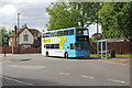
5
Bus in Tile Hill South turning circle
National Express Coventry 4688, a Volvo B7TL/Wright Eclipse Gemini, lays over in the turning circle at Tile Hill South before working a journey on route 18 to Coventry city centre via Canley and Hearsall Common. It will begin its journey by turning through 180 degrees to reach Station Avenue.
Image: © Richard Vince
Taken: 2 Apr 2016
0.10 miles
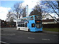
6
Bus terminus, Tile Hill
The traditional edge-of-town bus terminus is still alive and well in Coventry. Here a number 18 waits on Torrington Avenue, a few yards from Tile Hill Station, before returning to the city centre. See also Image
Image: © Stephen McKay
Taken: 14 Jul 2017
0.10 miles
7
Bus turning circle, Tile Hill South (1)
Built into the junction of Torrington Avenue (foreground) and Station Avenue, this turning circle is currently the terminus of routes 5, 18, and 18A. Despite being close to the west end of Tile Hill, buses terminating here have always shown Tile Hill South, presumably to differentiate them from those terminating at Tile Hill North (see Image).
Image: © Richard Vince
Taken: 2 Apr 2016
0.10 miles
8

Bus turning circle, Tile Hill South (2)
Built into the junction of Torrington Avenue (foreground) and Station Avenue (just visible on the left), this turning circle is currently the terminus of routes 5, 18 (on which the bus visible here is operating), and 18A. Despite being close to the west end of Tile Hill, buses terminating here have always shown Tile Hill South, presumably to differentiate them from those terminating at Tile Hill North (see Image).
Image: © Richard Vince
Taken: 2 Apr 2016
0.10 miles
9
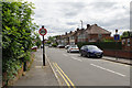
Hathaway Road, Tile Hill
Seen from Tile Hill Lane, Hathaway Road is a cul-de-sac of semi-detached houses.
Image: © Stephen McKay
Taken: 14 Jul 2017
0.13 miles
10
Hathaway Road Coventry
Looking towards Tile Hill Lane from Hathaway Avenue.
Image: © Malcolm Neal
Taken: 31 May 2018
0.15 miles