IMAGES TAKEN NEAR TO
Massey Close, COVENTRY, CV4 9GQ
Introduction
This page details the photographs taken nearby to Massey Close, CV4 9GQ by members of the Geograph project.
The Geograph project started in 2005 with the aim of publishing, organising and preserving representative images for every square kilometre of Great Britain, Ireland and the Isle of Man.

There are currently over 7.5m images from over14,400 individuals and you can help contribute to the project by visiting https://www.geograph.org.uk
Image Map
Images are licensed for reuse under creativecommons.org/licenses/by-sa/2.0
Notes
- Clicking on the map will re-center to the selected point.
- The higher the marker number, the further away the image location is from the centre of the postcode.
Image Listing (16 Images Found)
Images are licensed for reuse under creativecommons.org/licenses/by-sa/2.0
Image
Details
Distance
1
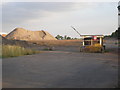
Behind the facade
This is the back entrance (from Broad Lane) to the former Massey Ferguson Works, Coventry. Although the facade of the offices (and the tower block) facing Banner Lane have been left standing, this is all that remains of the works.
The house builders' sales office is already in place at the far end of the site.
Image: © John Evans
Taken: 3 Aug 2006
0.04 miles
2
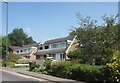
Banner Lane redevelopment
Showhomes on the Bannerbrook Park redevelopment of the former Massey Ferguson factory site.
Image: © E Gammie
Taken: 13 Nov 2011
0.16 miles
3
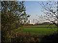
Farmland near Coventry
Looking across farmland towards the one remaining building of the former Massey Ferguson factory site - the office tower block (SP2779).
The same view in 2012: http://www.geograph.org.uk/photo/3030605
Image: © E Gammie
Taken: 13 Nov 2011
0.17 miles
4

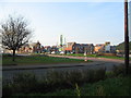
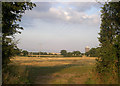
The edge of Coventry
Looking across arable farmland towards buildings at the former Massey Ferguson factory site. Missing from the horizon is the 17 storey tower block that was demolished earlier in the day.
The same view in 2011: http://www.geograph.org.uk/photo/2692180
Image: © E Gammie
Taken: 8 Jul 2012
0.18 miles
5
Hawkhurst Moor
According to the 1940's O.S. map Hawkhurst Moor Farm buildings would have been to the right of the picture.
It was on these fields that, in the late 80's, it was planned to build the largest coal mine in Europe. The Public Inquiry did not approve it.
The "remains" of the Massey Ferguson Works and the remaining tower block can be seen in the distance.
Image: © John Evans
Taken: 3 Aug 2006
0.19 miles
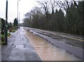
6
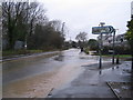
A little surface water
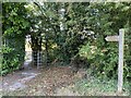
Heavy overnight and morning rain has caused excessive surface runoff from Hockley Lane on the right to add to the problems with an overflowing stream alongside Broad Lane. The stream is visible in front of the houses and passes under the road to continue behind the raised kerb on the left. By this time the rain had eased for a couple of hours.
Near the direction sign is a boundary post, marking the 1928 city boundary extension.
Image: © E Gammie
Taken: 13 Dec 2008
0.21 miles
8
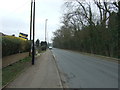
Broad Lane near Hockley Lane
After heavy overnight and morning rain has ameliorated, surface water flows down Broad Lane towards the junction with Banner Lane, covering most of the left hand side of the road. A stream runs behind the raised kerb on the right.
Image: © E Gammie
Taken: 13 Dec 2008
0.22 miles