IMAGES TAKEN NEAR TO
Tile Hill Lane, COVENTRY, CV4 9DG
Introduction
This page details the photographs taken nearby to Tile Hill Lane, CV4 9DG by members of the Geograph project.
The Geograph project started in 2005 with the aim of publishing, organising and preserving representative images for every square kilometre of Great Britain, Ireland and the Isle of Man.

There are currently over 7.5m images from over14,400 individuals and you can help contribute to the project by visiting https://www.geograph.org.uk
Image Map
Images are licensed for reuse under creativecommons.org/licenses/by-sa/2.0
Notes
- Clicking on the map will re-center to the selected point.
- The higher the marker number, the further away the image location is from the centre of the postcode.
Image Listing (70 Images Found)
Images are licensed for reuse under creativecommons.org/licenses/by-sa/2.0
Image
Details
Distance
1
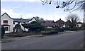
East end of Tile Hill Lane, Whoberley, Coventry
On old-maps.co.uk housing is shown extending along the north side of Tile Hill Lane from 1914. The house on the left appears between 1914 and 1925; the bungalow shows on a map of 1937 Image The block on the right appears in the 1970s and is a dental surgery.
Image: © Robin Stott
Taken: 8 Mar 2021
0.02 miles
2
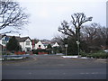
Tile Hill Lane
The eastern end of Tile Hill Lane was closed off when Coventry Business Park was constructed on the site of the Standard Triumph factory and a revised road layout was developed.
The building in the centre is one of the older structures on Tile Hill Lane.
Image: © E Gammie
Taken: 16 Jan 2013
0.02 miles
3
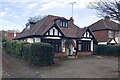
Classic bungalow, Tile Hill Lane, Whoberley, Coventry
On old-maps.co.uk housing is shown extending along the north side of Tile Hill Lane from 1914. This bungalow is first shown on a map of 1937 (as is the huge Standard Motor Works to the south). It looks as though a room has been created in the roofspace. The context is Image
Image: © Robin Stott
Taken: 8 Mar 2021
0.02 miles
4

Herald Avenue and Tile Hill Lane
Nearing sunset on the longest day of the year. The cloud effects are mostly decaying con-trails from planes heading for/leaving Birmingham airport, Elmdon. Time 21:15. Sunset 21:34.
Image: © E Gammie
Taken: 21 Jun 2010
0.03 miles
5
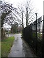
Tile Hill Lane
To the left, the remains of an old hedgerow separates the footway from the road. Ahead, Tile Hill Lane's route is diverted to the right to join the road system in Coventry Business Park. To the right, old railings formerly the northern boundary of the Standard Triumph site.
Image: © E Gammie
Taken: 13 Feb 2011
0.06 miles
6
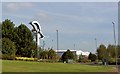
Sculpture on roundabout on the outskirts of Coventry
Stainless steel sculpture.
Image: © Steve Fareham
Taken: 13 Oct 2009
0.06 miles
7
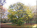
Maple, Hearsall Common
In among the oaks on the section of the common between Broad Lane and Tile Hill Lane.
Image: © E Gammie
Taken: 19 Nov 2008
0.07 miles
8

Hearsall Common, oaks
The footpath at the edge of Hearsall Common, between Broad Lane and Tile Hill Lane.
Image: © E Gammie
Taken: 9 Nov 2008
0.07 miles
9
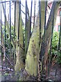
Tile Hill Lane
Tree and railings locked in battle alongside Tile Hill Lane. The railings stand on what was the northern boundary of the former Standard Triumph factory site. The buildings behind are part of the Coventry Business Park which was built on the site in the 1990s.
Image: © E Gammie
Taken: 13 Feb 2011
0.07 miles
10
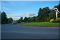
Whoberley : Tile Hill Lane
At the roundabout at Tile Hill Lane.
Image: © Lewis Clarke
Taken: 25 Sep 2021
0.07 miles