IMAGES TAKEN NEAR TO
Tile Hill Lane, COVENTRY, CV4 9DE
Introduction
This page details the photographs taken nearby to Tile Hill Lane, CV4 9DE by members of the Geograph project.
The Geograph project started in 2005 with the aim of publishing, organising and preserving representative images for every square kilometre of Great Britain, Ireland and the Isle of Man.

There are currently over 7.5m images from over14,400 individuals and you can help contribute to the project by visiting https://www.geograph.org.uk
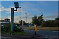
Image Map
Images are licensed for reuse under creativecommons.org/licenses/by-sa/2.0
Notes
- Clicking on the map will re-center to the selected point.
- The higher the marker number, the further away the image location is from the centre of the postcode.
Image Listing (58 Images Found)
Images are licensed for reuse under creativecommons.org/licenses/by-sa/2.0
Image
Details
Distance
1
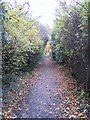
Tile Hill Lane footway
The southern side of Tile Hill Lane, separated from the road by the old hedgerow on the left.
Image: © E Gammie
Taken: 9 Nov 2008
0.04 miles
2
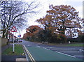
Tile Hill Lane
Looking east towards Hearsall Common. A mix of housing to the left, oaks in the old hedgerow to the right which separates the footway from the road. Behind the trees is the Coventry Business Park, occupying the former site of the Standard-Triumph car factory and its successors.
Tile Hill Lane was formerly a busy road, classified the B4101 to Knowle and Redditch, but has been superseded by the road system created for the business park. A bus lane at the junction with Fletchamstead Highway limits the traffic eastward to buses (in theory). Other vehicles can enter from the Hearsall Common end.
Image: © E Gammie
Taken: 15 Nov 2008
0.07 miles
3

Citro?n dealership, Herald Avenue, Coventry Business Park
Image: © Robin Stott
Taken: 6 Nov 2020
0.08 miles
4
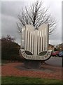
Memorial to site of Standard Triumph Factory
Image: © Jeff Tomlinson
Taken: 5 Apr 2004
0.11 miles
5

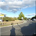
Renown Avenue, Coventry Business Park
Looking towards Herald Avenue and the small office units on the business park. An industrial unit on the right.
Image: © E Gammie
Taken: 25 Nov 2016
0.11 miles
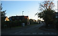
6
Herald Avenue
The B4101 from Tile Hill towards Coventry.
Image: © Gerald England
Taken: 24 Sep 2021
0.11 miles
7
Whoberley : Herald Avenue B4101
At the road junction with The Hill Lane in view.
Image: © Lewis Clarke
Taken: 25 Sep 2021
0.12 miles
8
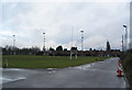
Old Coventrians ground
The rugby pitches at the Old Coventrians Rugby Club. The standing water reflects the dismal weather of Christmas morning which has brightened a little at midday. The club has further pitches and a bowling green to the right. A reminder of the days when factories and firms provided sports facilities for their employees - the Co-op and Renold Chain being two firms associated with these grounds in the past.
The houses in the background are late 20th century infill behind 1930s housing on Broad Lane.
Image: © E Gammie
Taken: 25 Dec 2012
0.12 miles
9
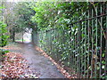
Tile Hill Lane railings
Old Standard Triumph factory railings to the right, old hedgerow to the left.
Image: © E Gammie
Taken: 13 Feb 2011
0.13 miles
10
Hendre Close
A 1960s in-fill cul-de-sac behind 1920s/30s housing on Broad Lane. The postbox a few yards into the close has been moved here from its former location outside the now-defunct Post Office at the corner of Glendower Avenue and Broad Lane ( Image] ).
Image: © E Gammie
Taken: 31 Oct 2015
0.13 miles