IMAGES TAKEN NEAR TO
Cherry Tree Drive, COVENTRY, CV4 8LZ
Introduction
This page details the photographs taken nearby to Cherry Tree Drive, CV4 8LZ by members of the Geograph project.
The Geograph project started in 2005 with the aim of publishing, organising and preserving representative images for every square kilometre of Great Britain, Ireland and the Isle of Man.

There are currently over 7.5m images from over14,400 individuals and you can help contribute to the project by visiting https://www.geograph.org.uk
Image Map
Images are licensed for reuse under creativecommons.org/licenses/by-sa/2.0
Notes
- Clicking on the map will re-center to the selected point.
- The higher the marker number, the further away the image location is from the centre of the postcode.
Image Listing (42 Images Found)
Images are licensed for reuse under creativecommons.org/licenses/by-sa/2.0
Image
Details
Distance
1
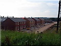
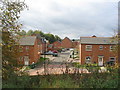
New housing, Canley
The last few houses in the 'White Willow Park' housing development are nearing completion. Seen from the A45 embankment.
Image: © E Gammie
Taken: 19 Sep 2015
0.01 miles
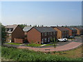
2
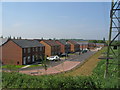
White Willow Park
Newly completed and occupied housing in Canley on the site of the former Sir Henry Parkes primary school.
Image: © E Gammie
Taken: 12 May 2016
0.04 miles
3
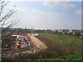
Development by the A45
The edge of the 'White Willow Park' housing development alongside the line of electricity pylons. The incomplete houses and plots display 'sold' signs.
Image: © E Gammie
Taken: 9 Apr 2015
0.04 miles
4
Apple Way
Part of the small estate built 2014-16 on the site of the former Sir Henry Parkes primary school. The builders equipment containers can still be seen at the end of the road
Image: © E Gammie
Taken: 12 May 2016
0.04 miles
5
Apple Way
Part of the small estate built on the site of the former Sir Henry Parkes primary school between 2014-16.
Image: © E Gammie
Taken: 14 Oct 2017
0.04 miles
6
White Willow Park
New housing in Canley on the site of the former Sir Henry Parkes primary school.
Image: © E Gammie
Taken: 12 May 2016
0.04 miles
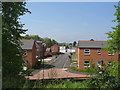
7

Towards Canley from the A45
Building in progress on the former Sir Henry Parkes primary school site. Beyond the site paraphernalia can be seen the rear of 1920s/30s-built houses in Queen Margaret's Road.
Image: © E Gammie
Taken: 20 Mar 2014
0.04 miles
8
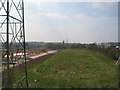
Green space
The 'White Willow Park' housing development by the A45 has been built up to but not beyond the line of electricity pylons parallel to the Coventry-Birmingham railway line on the right, leaving a narrow remnant of former playing fields.
Image: © E Gammie
Taken: 9 Apr 2015
0.05 miles
9

Cherry Tree Drive
The northern edge of the small estate built on the site of the former Sir Henry Parkes primary school between 2014-16. A small green space has been left between the power lines and the railway line.
Image: © E Gammie
Taken: 14 Oct 2017
0.08 miles
10
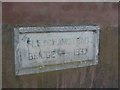
Fletchamstead Bridge parapet stone (W)
The stone incorporated into the western parapet of the bridge carrying the A45 Fletchamstead Highway over the Coventry-Birmingham railway line bears the inscription 'Fletchamstead Bridge - 1937'. The opposite parapet: Image]
Image: © E Gammie
Taken: 23 Dec 2009
0.08 miles