IMAGES TAKEN NEAR TO
Prior Deram Walk, COVENTRY, CV4 8FS
Introduction
This page details the photographs taken nearby to Prior Deram Walk, CV4 8FS by members of the Geograph project.
The Geograph project started in 2005 with the aim of publishing, organising and preserving representative images for every square kilometre of Great Britain, Ireland and the Isle of Man.

There are currently over 7.5m images from over14,400 individuals and you can help contribute to the project by visiting https://www.geograph.org.uk
Image Map
Images are licensed for reuse under creativecommons.org/licenses/by-sa/2.0
Notes
- Clicking on the map will re-center to the selected point.
- The higher the marker number, the further away the image location is from the centre of the postcode.
Image Listing (18 Images Found)
Images are licensed for reuse under creativecommons.org/licenses/by-sa/2.0
Image
Details
Distance
1
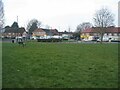
Prior Deram Walk
Shops and Canley Cummunity Centre.
Image: © E Gammie
Taken: 2 Mar 2021
0.10 miles


5
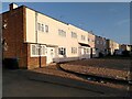
Coventry Corporation council housing, Sheriff Avenue, Canley
These houses were built in 1940-41 to designs by the City Architect's Department under the newly appointed Donald Gibson. They are contemporary, therefore, with the large air raids on Coventry and Gibson's first plans for a modern shopping precinct to be built as part of the reconstruction of the destroyed city centre.
These houses are in a modernist style, too, with flat roofs and plain brick walls, although most have since been rendered and the windows replaced. They were among the first council houses to be built in Canley, which was to become a large housing estate on the western edge of the city. Other houses built by the city in this area at the same time had more conventional pitched-roof designs. See Coventry: The making of a modern city by Jeremy Gould & Caroline Gould, p82, at the Historic England site https://historicengland.org.uk/images-books/publications/coventry-making-of-modern-city-1939-73/ . Similar houses on the opposite side of Sheriff Avenue can be seen at Image
Image: © A J Paxton
Taken: 26 May 2023
0.17 miles
6

Elmer the Patchwork Elephant, Canley Library
The multicoloured elephant from David McKee's series of picture books forms the subject of this pastel-shaded mural on the gable end of the library facing onto Prior Deram Walk.
Image: © A J Paxton
Taken: 7 Oct 2023
0.17 miles
7

Cherry Tree Drive
The northern edge of the small estate built on the site of the former Sir Henry Parkes primary school between 2014-16. A small green space has been left between the power lines and the railway line.
Image: © E Gammie
Taken: 14 Oct 2017
0.18 miles
8
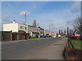
Sheriff Avenue, Canley
Houses on Sheriff Avenue, built 1940-41 to a design by city architect Donald Gibson.
Image: © E Gammie
Taken: 26 Feb 2016
0.21 miles
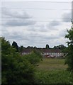
9

Towards Canley from the A45
Building in progress on the former Sir Henry Parkes primary school site. Beyond the site paraphernalia can be seen the rear of 1920s/30s-built houses in Queen Margaret's Road.
Image: © E Gammie
Taken: 20 Mar 2014
0.22 miles
10

Prior Deram park
New housing occupies the eastern end of the former recreation ground, with the western end retained as a playground and small green space.
Image: © E Gammie
Taken: 2 Mar 2021
0.22 miles