IMAGES TAKEN NEAR TO
John Rous Avenue, COVENTRY, CV4 8EU
Introduction
This page details the photographs taken nearby to John Rous Avenue, CV4 8EU by members of the Geograph project.
The Geograph project started in 2005 with the aim of publishing, organising and preserving representative images for every square kilometre of Great Britain, Ireland and the Isle of Man.

There are currently over 7.5m images from over14,400 individuals and you can help contribute to the project by visiting https://www.geograph.org.uk
Image Map
Images are licensed for reuse under creativecommons.org/licenses/by-sa/2.0
Notes
- Clicking on the map will re-center to the selected point.
- The higher the marker number, the further away the image location is from the centre of the postcode.
Image Listing (7 Images Found)
Images are licensed for reuse under creativecommons.org/licenses/by-sa/2.0
Image
Details
Distance
2
Charter Primary School, Canley Children?s Centre, Mitchell Avenue, Canley, Coventry
A Coventry City Council school. The sign at the gate carries the 'Sure Start' and NHS Coventry logos.
Image: © Robin Stott
Taken: 3 Aug 2013
0.18 miles
3
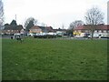
Prior Deram Walk
Shops and Canley Cummunity Centre.
Image: © E Gammie
Taken: 2 Mar 2021
0.20 miles
4

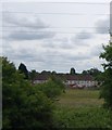
Cherry Tree Drive
The northern edge of the small estate built on the site of the former Sir Henry Parkes primary school between 2014-16. A small green space has been left between the power lines and the railway line.
Image: © E Gammie
Taken: 14 Oct 2017
0.22 miles
5
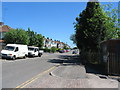
Torrington Avenue
Short terraces of 1920s/30s houses on the north side of the east end of Torrington Avenue. The south side is mainly industrial units.
Image: © E Gammie
Taken: 23 May 2010
0.24 miles

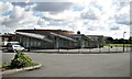
7
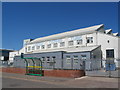
Factory and bus stop, Torrington Avenue
Torrington Avenue houses a mix of industrial and residential units.
Image: © E Gammie
Taken: 23 May 2010
0.24 miles