IMAGES TAKEN NEAR TO
The Laurels, Fairlands Park, COVENTRY, CV4 7PA
Introduction
This page details the photographs taken nearby to The Laurels, Fairlands Park, CV4 7PA by members of the Geograph project.
The Geograph project started in 2005 with the aim of publishing, organising and preserving representative images for every square kilometre of Great Britain, Ireland and the Isle of Man.

There are currently over 7.5m images from over14,400 individuals and you can help contribute to the project by visiting https://www.geograph.org.uk
Image Map
Images are licensed for reuse under creativecommons.org/licenses/by-sa/2.0
Notes
- Clicking on the map will re-center to the selected point.
- The higher the marker number, the further away the image location is from the centre of the postcode.
Image Listing (80 Images Found)
Images are licensed for reuse under creativecommons.org/licenses/by-sa/2.0
Image
Details
Distance
1
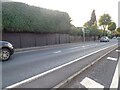
Earlsdon : Fletchamstead Highway A45
Looking along the road.
Image: © Lewis Clarke
Taken: 25 Sep 2021
0.02 miles
2
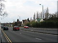
Fletchamstead Highway (A45)
Near the crossroads with Kenilworth Road (A429). A mix of detached and semi-detached houses alongside the road at this point.
Image: © E Gammie
Taken: 18 Apr 2010
0.02 miles
3
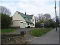
House on the corner
A house with distinctive green roof tiles, constructed c. 1956, next to the Kenilworth Road (A429)/Fletchamstead Highway (A45) crossroads, the traffic lights for which are visible on the right.
Image: © E Gammie
Taken: 18 Apr 2010
0.04 miles
4
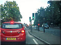
Earlsdon : Fletchamstead Highway A45
At the road junction waiting in traffic.
Image: © Lewis Clarke
Taken: 25 Sep 2021
0.06 miles
5
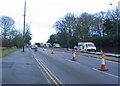
Roadworks, Fletchamstead Highway
Work under way to modify the right turns at the A45 Fletchamstead Highway/A429 Kenilworth Road crossroads. At this point, the separate right-turn lane onto Kenilworth Road is being removed.
Image: © E Gammie
Taken: 13 Jan 2014
0.06 miles
6
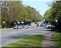
A429 Kenilworth Road towards Coventry
Looking towards the A45 crossroads.
Image: © Mat Fascione
Taken: 18 Apr 2015
0.06 miles
7
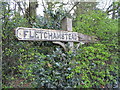
No 'Highway'
Looking a little worse for wear and slightly ovewhelmed by the hawthorn and holly hedge, this rustic style sign stands at the Kenilworth Road (A429)/Fletchamstead Highway (A45) crossroads.
Image: © E Gammie
Taken: 18 Apr 2010
0.06 miles
8
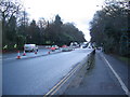
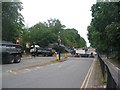
Roadworks, Kenilworth Road
Work under way to modify the right turns at the A429 Kenilworth Road/A45 Fletchamstead Highway crossroads and install pedestrian and cycle crossing phases.
Image: © E Gammie
Taken: 13 Jan 2014
0.07 miles
9
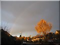
Cannon Close
A faint rainbow and evening sunlight on a silver birch. Detached houses of varying 20th century dates from the 1930s onward.
Image: © E Gammie
Taken: 12 Nov 2018
0.07 miles
10
Kenilworth Road, roadworks
A road planer at work removing the old surface during re-surfacing works at the crossroads of the A45 and Kenilworth Road (A429). The junction and approaches were closed from 6pm 10th May to 6am 11th May to do the work.
Image: © E Gammie
Taken: 10 May 2020
0.08 miles