IMAGES TAKEN NEAR TO
Cannon Park Road, COVENTRY, CV4 7AX
Introduction
This page details the photographs taken nearby to Cannon Park Road, CV4 7AX by members of the Geograph project.
The Geograph project started in 2005 with the aim of publishing, organising and preserving representative images for every square kilometre of Great Britain, Ireland and the Isle of Man.

There are currently over 7.5m images from over14,400 individuals and you can help contribute to the project by visiting https://www.geograph.org.uk
Image Map
Images are licensed for reuse under creativecommons.org/licenses/by-sa/2.0
Notes
- Clicking on the map will re-center to the selected point.
- The higher the marker number, the further away the image location is from the centre of the postcode.
Image Listing (206 Images Found)
Images are licensed for reuse under creativecommons.org/licenses/by-sa/2.0
Image
Details
Distance
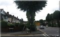
1
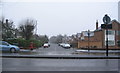
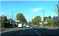
Cannon Park Road
Looking across Fletchamstead Highway (A45) to Cannon Park Road. The houses on the left were built c. 1930s facing an open space the length of the road. The group of houses on the right were added at the highway end c. 1960s. The rest of the right hand side of the road remains undeveloped.
Image: © E Gammie
Taken: 29 Jan 2015
0.03 miles
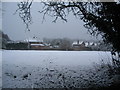
2
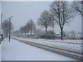
Fletchamstead Highway
Snow falling steadily had accumulated to over 10cms depth by this time and continued to fall into the evening, although not greatly increasing in depth.
Image: © E Gammie
Taken: 10 Dec 2017
0.05 miles
3
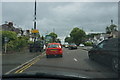
Rain and traffic on the A45
Some of the less enjoyable aspects of driving, in this case on Coventry's outer ring road.
Image: © Bill Boaden
Taken: 26 Jun 2015
0.07 miles
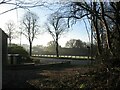
4
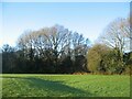
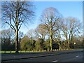
Trees alongside Fletchamstead Highway
A green space alongside the A45 (Fletchamstead Highway) and bordering Canley Brook. These are mostly ash with an under-storey of hawthorn (probably old boundary remnants) and ivy. There's a noticeable depression in the foreground which must drain well as it's not waterlogged despite heavy overnight rain.
Image: © E Gammie
Taken: 27 Dec 2020
0.07 miles
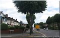
5
Houses by Fletchamstead Highway
The green space east of Canley brook and c. 1960s houses - those on the left face the A45 and those on the right are off Cannon Park Road.
Image: © E Gammie
Taken: 14 Jan 2013
0.07 miles
6
Frosty morning, Fletchamstead Highway
Looking across the A45 from the footpath to Canley Ford open space.
Image: © E Gammie
Taken: 23 Nov 2020
0.07 miles
7
Shared use path, A45 Fletchamstead Highway
At the junction with Cannon Close. Shared use: pedestrians and cyclists share with trees; telegraph poles; streetlights; road signs; a bus stop; assorted random temporary signs and several dropped kerbs.
Image: © E Gammie
Taken: 10 Jul 2020
0.08 miles
8
Shared use path, A45 Fletchamstead Highway
At the junction with Cannon Close. Shared use: pedestrians and cyclists share with trees; telegraph poles; streetlights; road signs; a bus stop; assorted random temporary signs and several dropped kerbs. Visibility had improved since the morning : Image The temporary signs warn of imminent surface dressing work, i.e. gravel spattering.
Image: © E Gammie
Taken: 10 Jul 2020
0.08 miles
10
Fletchamstead Highway
Looking across the A45 (Fletchamstead Highway) towards Tutbury Fields open space bordering Canley Brook.
Image: © E Gammie
Taken: 27 Dec 2020
0.09 miles