IMAGES TAKEN NEAR TO
Cryfield Grange Road, COVENTRY, CV4 7AQ
Introduction
This page details the photographs taken nearby to Cryfield Grange Road, CV4 7AQ by members of the Geograph project.
The Geograph project started in 2005 with the aim of publishing, organising and preserving representative images for every square kilometre of Great Britain, Ireland and the Isle of Man.

There are currently over 7.5m images from over14,400 individuals and you can help contribute to the project by visiting https://www.geograph.org.uk
Image Map
Images are licensed for reuse under creativecommons.org/licenses/by-sa/2.0
Notes
- Clicking on the map will re-center to the selected point.
- The higher the marker number, the further away the image location is from the centre of the postcode.
Image Listing (20 Images Found)
Images are licensed for reuse under creativecommons.org/licenses/by-sa/2.0
Image
Details
Distance
1
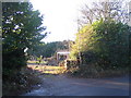
Empty plot, Cryfield Grange Road
The fire-damaged house in Cryfield Grange Road, visible in Image, has now been demolished, leaving the garage.
Cryfield Grange Road is a narrow lane between Kenilworth Road and Crackley Lane running past Cryfield Grange.
Image: © E Gammie
Taken: 6 Dec 2008
0.03 miles
2
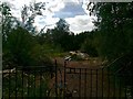
Poynton Birches, Cryfield Grange Road
Demolished
Image: © Alex McGregor
Taken: 9 Jun 2011
0.03 miles
3
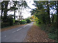
Cryfield Grange Road
Rapidly narrows to single track. The large house on the left was gutted by fire in 2000, since which time it has awaited its fate (probably demolition and redevelopment) whilst encased in scaffolding and slowly shredding plastic sheeting.
Update Dec 2008: The building has now been demolished. See Image
Image: © E Gammie
Taken: 2 Nov 2007
0.04 miles
4
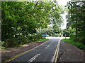
Cryfield Grange Rd
View east along Cryfield Grange Rd towards its junction with the Kenilworth Rd.
Image: © Nigel Mykura
Taken: 13 Aug 2010
0.09 miles
5
Very large detached house off Kenilworth Road, Coventry
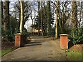
There are many such properties especially on the west side of Kenilworth Road. Few can be seen: the gate pillars signal a large house set back beyond the great trees lining the road and screened by evergreen shrubs. Estimated location.
Image: © Robin Stott
Taken: 23 Feb 2021
0.10 miles
7
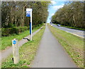
Bus stop along the A429 Kenilworth Road
Looking up the hill towards the Gibbet Hill crossroads.
Image: © Mat Fascione
Taken: 18 Apr 2015
0.10 miles
8
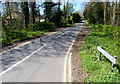
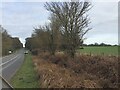
Kenilworth Road, Coventry, looking towards Crackley
This is the downward slope of the road from Gibbet Hill towards the Finham Brook, leading out of Coventry towards Kenilworth. The Kenilworth Road is straight and lined with spinneys planted in the 18th century; the land was bought by the city council in 1926 and is now a conservation area; see Image This is one of very few roads in the Coventry and Warwickshire area highlighted in green on the French Michelin map, indicating a scenic route. It does indeed have a rather formal, French kind of beauty, with long straight vistas lined with trees.
Image: © A J Paxton
Taken: 11 May 2023
0.11 miles
9
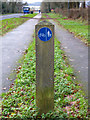
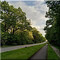
Cycle path on Kenilworth Road
Along the north western side of Kenilworth Road runs a cycle path next to the road, and a separate pavement for pedestrians further away.
This is infinitely preferable to the joint routes one often encounters, with their ever present danger of being run over from behind by a cyclist.
Image: © David P Howard
Taken: 4 Jan 2013
0.11 miles
10
A429 Kenilworth Road enters Coventry from the south
This is the start of a magnificent avenue of mature oak and beech that runs straight for over 3 km towards the city: Image, Image
Image: © Robin Stott
Taken: 23 Feb 2021
0.15 miles