IMAGES TAKEN NEAR TO
Sandstone Place, CV47 2PB
Introduction
This page details the photographs taken nearby to Sandstone Place, CV47 2PB by members of the Geograph project.
The Geograph project started in 2005 with the aim of publishing, organising and preserving representative images for every square kilometre of Great Britain, Ireland and the Isle of Man.

There are currently over 7.5m images from over14,400 individuals and you can help contribute to the project by visiting https://www.geograph.org.uk
Image Map
Images are licensed for reuse under creativecommons.org/licenses/by-sa/2.0
Notes
- Clicking on the map will re-center to the selected point.
- The higher the marker number, the further away the image location is from the centre of the postcode.
Image Listing (12 Images Found)
Images are licensed for reuse under creativecommons.org/licenses/by-sa/2.0
Image
Details
Distance
1
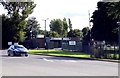
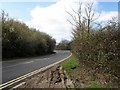
Old Line of the B4100
This short stretch of tarmac used to be the B41oo when it ran through the army camp at Kineton. However the road was rerouted to bypass the army houses and a short access road was built to join the new and old roads. The old road has been blocked off where the post can be seen in the distance leaving this short layby. A bridle path still runs along this route.
Image: © Nigel Mykura
Taken: 14 Sep 2012
0.13 miles
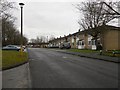
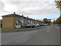
2
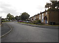
Falklands Place
This is the main residential housing estate connected with the large army base at Kineton. The base is one of the armies main munitions depots.
Image: © Nigel Mykura
Taken: 14 Sep 2012
0.14 miles
3
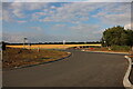
New roundabout on Banbury Road, Preston Herdewyke
This is for the new housing development, The Templars https://mulberryhomes.co.uk/developments/the-templars/overview/
Image: © David Howard
Taken: 1 Aug 2021
0.16 miles
5
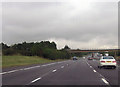
Railway bridge near Little Dassett
Over M40 north
Image: © John Firth
Taken: 26 Sep 2012
0.18 miles
6
Temple Herdewyke
Ministry of Defence housing.
Image: © Ian Rob
Taken: 21 Dec 2011
0.18 miles
7
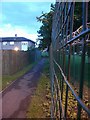
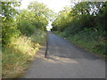
Perimeter fence, DMC Kineton
Looking along the path separating some of the accommodation (actually, the most southerly block) and the perimeter fence of Marlborough Barracks, at Temple Herdewyke.
Image: © David Luther Thomas
Taken: 23 Jun 2007
0.19 miles

9
Falklands Place
This road is part of the large residential estate associated with the Kineton Army Base, the base is the main munitions store for the army and used to be known as CAD which was presumably Central Ammunitions Depot.
Image: © Nigel Mykura
Taken: 14 Sep 2012
0.22 miles