IMAGES TAKEN NEAR TO
Wimpstone, STRATFORD-UPON-AVON, CV37 8NW
Introduction
This page details the photographs taken nearby to Wimpstone, CV37 8NW by members of the Geograph project.
The Geograph project started in 2005 with the aim of publishing, organising and preserving representative images for every square kilometre of Great Britain, Ireland and the Isle of Man.

There are currently over 7.5m images from over14,400 individuals and you can help contribute to the project by visiting https://www.geograph.org.uk
Image Map
Images are licensed for reuse under creativecommons.org/licenses/by-sa/2.0
Notes
- Clicking on the map will re-center to the selected point.
- The higher the marker number, the further away the image location is from the centre of the postcode.
Image Listing (6 Images Found)
Images are licensed for reuse under creativecommons.org/licenses/by-sa/2.0
Image
Details
Distance
1
New building
This recently erected large shed is in the angle of the minor road and the driveway to Wimpstone Fields Farm.
Image: © Michael Dibb
Taken: 18 Dec 2011
0.09 miles
2
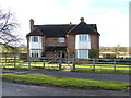
The Leys
This property alongside the minor road appears to have once been a farm, and indeed, there is a sign "Leys Farm" on the fence opposite the house. At the side of the house are some disused glasshouses and some sheds.
Image: © Michael Dibb
Taken: 18 Dec 2011
0.09 miles
3
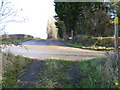
Path crosses road
The footpath from Admington meets the minor road. The path carries on across the road and runs as far as Wimpstone Fields Farm. It is noticeable that whilst there is a new footpath sign for the path on this side of the road, there is no signpost to show that there is a path on the other side of the road.
Image: © Michael Dibb
Taken: 18 Dec 2011
0.11 miles
4
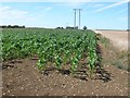
Powerlines near Tranquille
On the opposite side of the road to Crimscote Downs , these powerlines run close to a field boundary between a maize field and a wheat field.
Image: © Nigel Mykura
Taken: 24 Jul 2011
0.19 miles
5
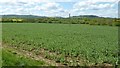
View to the northern Cotswold Hills
View across farmland around Admington to two of the most northerly Cotswold Hills. Most of the Cotswold Hills are within the county Gloucestershire, some in South Gloucestershire, Worcestershire and reaching eastwards to include a little of Oxfordshire. These two hills are Ilmington Down on the left, and the outlier of Meon Hill on the right. Meon Hill is the only Cotswold outlier in the county of Warwickshire, while Ilmington Down it the highest point in Warwickshire.
Image: © Philip Halling
Taken: 25 Apr 2017
0.21 miles
6
![Wimpstone Fields Farm [2]](https://s0.geograph.org.uk/geophotos/02/80/38/2803896_46456283_120x120.jpg)
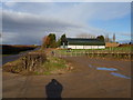
Wimpstone Fields Farm [2]
The farm intensively rears poultry. These are the poultry sheds seen, across the field, from the driveway.
Image: © Michael Dibb
Taken: 18 Dec 2011
0.24 miles