IMAGES TAKEN NEAR TO
Dingles Way, STRATFORD-UPON-AVON, CV37 6XN
Introduction
This page details the photographs taken nearby to Dingles Way, CV37 6XN by members of the Geograph project.
The Geograph project started in 2005 with the aim of publishing, organising and preserving representative images for every square kilometre of Great Britain, Ireland and the Isle of Man.

There are currently over 7.5m images from over14,400 individuals and you can help contribute to the project by visiting https://www.geograph.org.uk
Image Map (Loading...)


Getting Data...Please wait
Leaflet Map data © OpenStreetMap
Images are licensed for reuse under creativecommons.org/licenses/by-sa/2.0
Notes
- Clicking on the map will re-center to the selected point.
- The higher the marker number, the further away the image location is from the centre of the postcode.
Image Listing (36 Images Found)
Images are licensed for reuse under creativecommons.org/licenses/by-sa/2.0
Image
Details
Distance
1
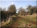
Footpath to Stratford
A kissing gate on the footpath to Stratford as it enters the housing estate.
Image: © David P Howard
Taken: 2 Mar 2010
0.05 miles
2
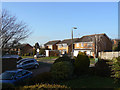
Swift Road
Late 20th century development on the slopes of Clopton Hill.
Image: © Alan Murray-Rust
Taken: 6 Mar 2011
0.05 miles
3
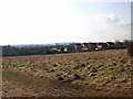
View southwest from Clopton Tower
View SW standing on Monarch's Way close to Clopton Tower. Image
Image: © David P Howard
Taken: 2 Mar 2010
0.06 miles
4
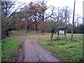
Bluecap Covert
The footpath to Snitterfield passes through this covert on the western edge of Welcombe Park.
Image: © David Stowell
Taken: 13 Dec 2005
0.07 miles
5
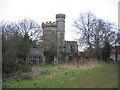
Clopton House Tower
This octagonal three storey building, complete with battlements, sits on the hill overlooking Stratford-upon-Avon. The Clopton family were benefactors of Stratford-upon-Avon from around the time of Shakespeare's father. The tower was designed as a belvedere for Clopton House and has been described as either "the smallest castle or grandest cottage in England"! The building was carefully converted into a private house in the 1990's, and a new section has been added in identical style complete with matching stone and battlements.
Image: © David Stowell
Taken: 13 Dec 2005
0.07 miles
6
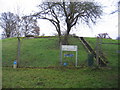
Footpath by Deer Park Court
Looking north from near Clopton Tower towards Bluecap Covert.
Image: © David Stowell
Taken: 13 Dec 2005
0.07 miles
7
Welcombe Park service reservoir
Looking east at the reservoir, shown on the OS map, at Bluecap Covert.
Image: © David Stowell
Taken: 13 Dec 2005
0.07 miles
8
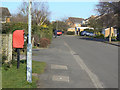
Blue Cap Road
Looking northeast from Blackthorn Road. This section of the road is still identified on OS maps as a footpath right of way. The postbox is named as Blue Cap Lane ref. CV37 102.
Image: © Alan Murray-Rust
Taken: 6 Mar 2011
0.07 miles
9
Monarch's Way leaving Stratford-upon-Avon
The footpath towards Snitterfield starting at the end of Maidenhead Road
Image: © Tim Heaton
Taken: 25 Apr 2009
0.08 miles
10
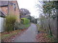
Monarch's Way at Clopton
This section of footpath to the north of Maidenhead Road appears always to have been hedged or fenced on both sides. The Monarch's Way follows the route taken by Charles II after the battle of Worcester - as best as appropriate modern rights of way allow - and at 990km is the second longest waymarked footpath in England.
Image: © Alan Murray-Rust
Taken: 6 Mar 2011
0.09 miles