IMAGES TAKEN NEAR TO
Grasmere Avenue, COVENTRY, CV3 6AY
Introduction
This page details the photographs taken nearby to Grasmere Avenue, CV3 6AY by members of the Geograph project.
The Geograph project started in 2005 with the aim of publishing, organising and preserving representative images for every square kilometre of Great Britain, Ireland and the Isle of Man.

There are currently over 7.5m images from over14,400 individuals and you can help contribute to the project by visiting https://www.geograph.org.uk
Image Map
Images are licensed for reuse under creativecommons.org/licenses/by-sa/2.0
Notes
- Clicking on the map will re-center to the selected point.
- The higher the marker number, the further away the image location is from the centre of the postcode.
Image Listing (70 Images Found)
Images are licensed for reuse under creativecommons.org/licenses/by-sa/2.0
Image
Details
Distance
1
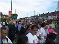
Next, the park
Crowds dispersing at the junction of Woodside Avenue North with Kenpas Highway after watching the Olympic torch relay pass by. Many will head to the nearby Memorial Park to watch it arrive at the end of the day's run.
Image: © E Gammie
Taken: 1 Jul 2012
0.09 miles
2
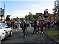
Waiting for the torch
About 15 minutes before the Olympic torch relay was due to arrive, the road has been closed and the swelling crowd has lined both sides of the eastbound carriageway of Kenpas Highway.
Image: © E Gammie
Taken: 1 Jul 2012
0.09 miles
3

The Burnt Post, Kenpas Highway
The Burnt Post public house takes its name from a former hamlet shown on old Ordnance Survey maps (1888-1913 six inch) as located at Image The pub is contemporary with the surrounding 1920s/30s housing and shops.
The photograph was taken on the first day of Covid-19 Tier 4 restrictions in Coventry which, amongst other things, restricted indoor socialising and required closure of indoor entertainment venues.
Image: © E Gammie
Taken: 31 Dec 2020
0.10 miles
4
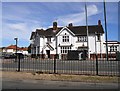
Coventry-The Burnt Post
Public House on Kenpas Highway.
Image: © Ian Rob
Taken: 8 Sep 2012
0.11 miles
5
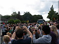
Olympic torch bearer, Kenpas Highway
After being carried on a coach the short distance down the Kenilworth Road from the outskirts of Kenilworth, the torch is back on the road in the hands of the first runner on the Coventry leg, Marion Childs.
From here, the torch route continued down the highway, turned left onto Leamington Road (B4113), left again onto Kenilworth Road (A429) then into the Memorial Park where it ended the day - a circuit of approximately 2.5 miles. This meant that those watching it here had time to walk down to the park and see it arrive.
Image: © E Gammie
Taken: 1 Jul 2012
0.11 miles
6
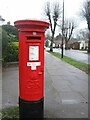
Woodside Avenue, priority postbox
Stickers indicate that this is a priority postbox during the Covid-19 pandemic.
Image: © E Gammie
Taken: 23 Dec 2020
0.11 miles
7
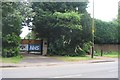
Thank you NHS and key workers
During the Covid-19 pandemic messages of support for NHS staff and other key workers started to appear in many places. Several included a rainbow image, as seen here on Kenilworth Road.
Image: © E Gammie
Taken: 10 May 2020
0.13 miles
8
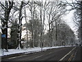
Stivichall Common
Trees bordering Coat of Arms Bridge Road show graphically the prevailing wind direction for the previous night's snow fall.
Image: © E Gammie
Taken: 24 Mar 2013
0.13 miles
9
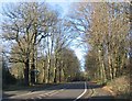
Coat of Arms Bridge Road
Trees on Stivichall Common bordering Coat of Arms Bridge Road.
Image: © E Gammie
Taken: 8 Dec 2016
0.14 miles
10
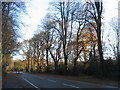
Coat of Arms Bridge Road and Stivichall Common
Trees on Stivichall Common highlighted by some welcome sunshine on Christmas Day.
Image: © E Gammie
Taken: 25 Dec 2019
0.14 miles