IMAGES TAKEN NEAR TO
Kenpas Highway, COVENTRY, CV3 6AW
Introduction
This page details the photographs taken nearby to Kenpas Highway, CV3 6AW by members of the Geograph project.
The Geograph project started in 2005 with the aim of publishing, organising and preserving representative images for every square kilometre of Great Britain, Ireland and the Isle of Man.

There are currently over 7.5m images from over14,400 individuals and you can help contribute to the project by visiting https://www.geograph.org.uk
Image Map
Images are licensed for reuse under creativecommons.org/licenses/by-sa/2.0
Notes
- Clicking on the map will re-center to the selected point.
- The higher the marker number, the further away the image location is from the centre of the postcode.
Image Listing (40 Images Found)
Images are licensed for reuse under creativecommons.org/licenses/by-sa/2.0
Image
Details
Distance
1
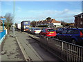
Kenpas Highway (A45) Coventry
Normal workday morning rush on the Kenpas Highway.
Image: © Peterson Cobbett
Taken: 28 Mar 2006
0.03 miles
4
Coventry-The Burnt Post
Public House on Kenpas Highway.
Image: © Ian Rob
Taken: 8 Sep 2012
0.05 miles
5
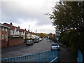
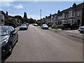
Green Lane (north), Finham
Green Lane is divided into two sections by Kenpas Highway, part of the Coventry southern bypass (which is part of the A45 at this point). This is the shorter northern section. The blue railings line the ramp access to a pedestrian subway under Kenpas Highway.
Image: © Richard Vince
Taken: 10 Nov 2012
0.06 miles
6

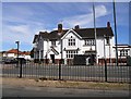
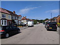
The Burnt Post, Kenpas Highway
The Burnt Post public house takes its name from a former hamlet shown on old Ordnance Survey maps (1888-1913 six inch) as located at Image The pub is contemporary with the surrounding 1920s/30s housing and shops.
The photograph was taken on the first day of Covid-19 Tier 4 restrictions in Coventry which, amongst other things, restricted indoor socialising and required closure of indoor entertainment venues.
Image: © E Gammie
Taken: 31 Dec 2020
0.06 miles
7
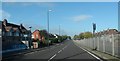
Green Lane off Kenpas Highway
The northern end of Green Lane, seen from near its junction with Kenpas Highway which separates it from its southern half accessible by pedestrians and cyclists via the subway. The appearance of the large mast has been altered and a communications box has been removed since 2020 (Image]).
A similar view in 2005: Image]
Image: © E Gammie
Taken: 5 Apr 2021
0.06 miles
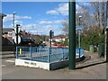
9
Green Lane subway
The pedestrian subway linking the north part of Green Lane with its southern part. The construction of the A45 southern bypass in the 1930s cut the road in two although I believe that, at the time, all road junctions were retained, later to be reduced to non-crossing junctions. The subway, like many of the underbridges along the bypass, has a stencilled number - 247 70 1 in this case. The adjacent railway underbridge has the number 247 70.
Image: © E Gammie
Taken: 16 Apr 2020
0.07 miles
10

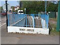
Bridge parapet date stone (SW), Kenpas Highway
The date stone on the south-western parapet of the bridge carrying the A45 over the Coventry-Leamington railway at Green Lane reads "Green Lane Bridge - 1937". There is a similar stone on the opposite parapet with different details: Image] .
Image: © E Gammie
Taken: 24 Aug 2020
0.08 miles