IMAGES TAKEN NEAR TO
Postbridge Road, COVENTRY, CV3 5AF
Introduction
This page details the photographs taken nearby to Postbridge Road, CV3 5AF by members of the Geograph project.
The Geograph project started in 2005 with the aim of publishing, organising and preserving representative images for every square kilometre of Great Britain, Ireland and the Isle of Man.

There are currently over 7.5m images from over14,400 individuals and you can help contribute to the project by visiting https://www.geograph.org.uk
Image Map
Images are licensed for reuse under creativecommons.org/licenses/by-sa/2.0
Notes
- Clicking on the map will re-center to the selected point.
- The higher the marker number, the further away the image location is from the centre of the postcode.
Image Listing (12 Images Found)
Images are licensed for reuse under creativecommons.org/licenses/by-sa/2.0
Image
Details
Distance
1
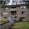
Entrance to flats on Gregory Hood Road, Coventry
This is a close up of an entrance to the flats depicted at Image The glazed tiles with flat numbers and a pastel-shaded surround (a different colour for each entrance) are details that show care and concern for tenants and their environment. These flats date from 1950-51; later on, pressure on the council to build fast and cheap would lead to the shoddiness seen, for example, at Image
Image: © A J Paxton
Taken: 29 Aug 2023
0.10 miles
2
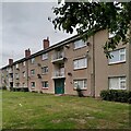
Block of flats on Gregory Hood Road, the Stonebridge Estate
These council flats were built in 1950-51 by Wimpey, using the 'no fines' method (concrete without fine, sandy aggregates, a cheaper method of building) for the Coventry City Architect's Department under Donald Gibson. See Image] for further information.
Image: © A J Paxton
Taken: 29 Aug 2023
0.12 miles
3
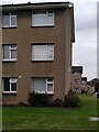
Mass-produced housing: Blocks of flats, Fred Lee Grove
These three-storey blocks on the Stonebridge estate on the southern edge of Coventry were built in 1950-51 by Wimpey to the designs of the City Architect's Department under Donald Gibson. See Image] for more information. In the words of Jeremy & Caroline Gould, "The monotony... was disappointing and the experiment proved that, since the houses were architecturally modest, it would require imaginative layout, varied density and a richer landscape to make distinctive places." See their e-book, 'Coventry, the making of a modern city 1939-73', p84, at the Historic England site https://historicengland.org.uk/images-books/publications/coventry-making-of-modern-city-1939-73/ . How many volume housebuilders today would even attempt to make 'distinctive places'?
Image: © A J Paxton
Taken: 29 Aug 2023
0.12 miles
4
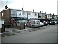
Shopping Parade in Dawlish Drive
Shops at the end of Knoll Drive.
Image: © Ian Rob
Taken: 10 Oct 2009
0.19 miles
5
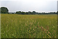
Whitley Common, Stivichall, Coventry, early summer
A gap in the trees reveals the A444, a road to and from the city centre. The blobby brown grass in the foreground is Cocksfoot. Colour in the distance is from buttercups and a sorrel species. I may be wrong to call this land – between Leaf Lane and the dual carriageway – Whitley Common; there is no name on the map.
Image: © Robin Stott
Taken: 8 Jun 2016
0.21 miles
6
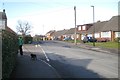
Okehampton Road, Stivichall, Coventry
One of several residential roads with Devonshire and West Country names.
Image: © Robin Stott
Taken: 17 Feb 2015
0.22 miles
7
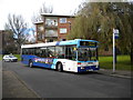
Confused bus, Charminster Drive, Fenside
This Mercedes O.405N, operated by National Express Coventry, appears to know where it's going, but seems confused about how to get there. "City Centre via Cheylesmore" would be more appropriate.
Image: © Richard Vince
Taken: 10 Nov 2012
0.22 miles
9
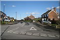
Chatsworth Rise, Stivichall, Coventry
Seen from Okehampton Road.
Image: © Robin Stott
Taken: 17 Feb 2015
0.23 miles
10
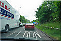
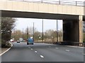
Stopped traffic on the Stivichall roundabout
Roadworks are being undertaken on the eastbound sliproad, causing the roundabout itself to be at a standstill.
Image: © Bill Boaden
Taken: 26 Jun 2015
0.25 miles