IMAGES TAKEN NEAR TO
Brookside Avenue, WARWICK, CV35 9RZ
Introduction
This page details the photographs taken nearby to Brookside Avenue, CV35 9RZ by members of the Geograph project.
The Geograph project started in 2005 with the aim of publishing, organising and preserving representative images for every square kilometre of Great Britain, Ireland and the Isle of Man.

There are currently over 7.5m images from over14,400 individuals and you can help contribute to the project by visiting https://www.geograph.org.uk
Image Map
Images are licensed for reuse under creativecommons.org/licenses/by-sa/2.0
Notes
- Clicking on the map will re-center to the selected point.
- The higher the marker number, the further away the image location is from the centre of the postcode.
Image Listing (86 Images Found)
Images are licensed for reuse under creativecommons.org/licenses/by-sa/2.0
Image
Details
Distance
1
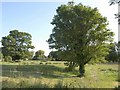
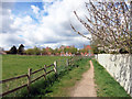
Pasture by the Dene
The River Dene runs past the trees in the background on the right. This view is from the footpath between Wellesbourne and the Mill.
Image: © Derek Harper
Taken: 11 Jun 2011
0.07 miles
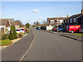
2
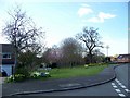
Green space at junction of Willow Drive and Brookside Avenue
A green space with spring flowers on this residential road.
Image: © David P Howard
Taken: 8 Apr 2010
0.09 miles
3
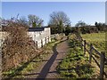
Footpath to Kineton Road
The footpath from Lowes Lane to Kineton Road on New Year's Day 2013.
Image: © David P Howard
Taken: 1 Jan 2013
0.09 miles
4
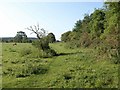
Meadow by the Dene
With an overgrown hedge on the right (the river forms the opposite boundary to this). A thin rectangular field, crossed by the footpath from Wellesbourne to Home Farm.
Image: © Derek Harper
Taken: 11 Jun 2011
0.09 miles
5
Willow Drive
Looking up Willow Drive towards the junction with the B4086 Kineton Road.
Image: © David P Howard
Taken: 17 Feb 2013
0.10 miles
6
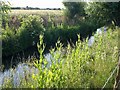
River Dene
Teasels, elder and grasses in morning sunshine beside the river upstream from Wellesbourne. This is looking upstream from the field shown in Image
Image: © Derek Harper
Taken: 11 Jun 2011
0.11 miles
7
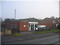
Wellesbourne Telephone Exchange
Beside the Kineton Road.
Image: © David Stowell
Taken: 11 Dec 2005
0.11 miles
8
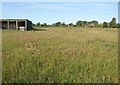
Pasture, Wellesbourne
The next grass field to Image passed by the footpath that heads up the River Dene valley, with houses on Lowes Lane and Walton Way in the distance.
Image: © Derek Harper
Taken: 11 Jun 2011
0.12 miles
9
Footpath into Wellesbourne
This footpath has followed the River Dene for a couple of miles south of here and continues in a similar way on the other side of Wellesbourne towards Charlecote Manor.
Image: © Des Blenkinsopp
Taken: 28 Apr 2016
0.13 miles
10
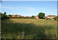
Grass field, Wellesbourne
Another view across Image from the footpath that heads up the Dene. The houses are on Lowes Lane.
Image: © Derek Harper
Taken: 11 Jun 2011
0.14 miles