IMAGES TAKEN NEAR TO
Wellesbourne, WARWICK, CV35 9RE
Introduction
This page details the photographs taken nearby to CV35 9RE by members of the Geograph project.
The Geograph project started in 2005 with the aim of publishing, organising and preserving representative images for every square kilometre of Great Britain, Ireland and the Isle of Man.

There are currently over 7.5m images from over14,400 individuals and you can help contribute to the project by visiting https://www.geograph.org.uk
Image Map
Images are licensed for reuse under creativecommons.org/licenses/by-sa/2.0
Notes
- Clicking on the map will re-center to the selected point.
- The higher the marker number, the further away the image location is from the centre of the postcode.
Image Listing (115 Images Found)
Images are licensed for reuse under creativecommons.org/licenses/by-sa/2.0
Image
Details
Distance
1
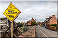
Election poster on Chapel Street
An election poster for the General Election and District Council Election held on 7th. May 2015.
Image: © David P Howard
Taken: 7 May 2015
0.04 miles
2
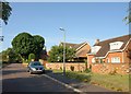
Lowes Lane, Wellesbourne
With an open field on the left, this road along the southeast edge of one of Wellesbourne's housing estates hints at a rural character. The visibility splay on the right is for the benefit of a small cul-de-sac called Holly Lodge.
Image: © Derek Harper
Taken: 11 Jun 2011
0.04 miles
3

Building work on the Donkey Field
New houses are being built on the Donkey Field despite much local opposition.
View SSE up Lowes Lane.
Image: © David P Howard
Taken: 7 Jun 2014
0.05 miles
4
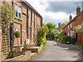
Garden Terrace, Wellesbourne
A small terrace in the old village area.
Image: © David P Howard
Taken: 15 May 2013
0.05 miles
5
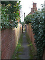
Passageway to Lowes Lane
A short passageway linking Ettington Road with Lowes Lane.
Image: © David P Howard
Taken: 6 Jan 2014
0.05 miles
6
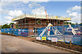
Building work on the Donkey Field
New houses are being built on the Donkey Field despite much local opposition.
View ENE down Lowes Lane.
Image: © David P Howard
Taken: 7 Jun 2014
0.05 miles
7
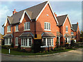
The show house is open
The first of five houses built on the Donkey Field off Lowes Lane is now completed and opened as a show house.
The new close has been called Long Ground, I believe after the original name of the field.
For an earlier stage in construction see Image
Image: © David P Howard
Taken: 27 Oct 2014
0.05 miles
8
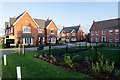
The new houses are finished
The five new houses built by Cala Homes on what was known locally as the Donkey Field appear to be finished and ready for occupation. The new road is called Long Ground after the original name of the land, and is off Lowes Lane.
Taken on a walk round the village on Xmas Day.
See also Image
Image: © David P Howard
Taken: 25 Dec 2014
0.06 miles
9
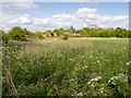
The Donkey Field
Looking across the field off Lowes Lane that used to contain donkeys, but is now threatened with new housing. Taken from the footpath to Walton Lane.
Image: © David P Howard
Taken: 15 May 2013
0.06 miles
10
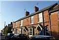
Brick terrace, Wellesbourne
Decorative brickwork and curvy porch bargeboards on these buildings on Chapel Street.
Image: © Derek Harper
Taken: 11 Jun 2011
0.06 miles