IMAGES TAKEN NEAR TO
Fulbrook Lane, WARWICK, CV35 8AS
Introduction
This page details the photographs taken nearby to Fulbrook Lane, CV35 8AS by members of the Geograph project.
The Geograph project started in 2005 with the aim of publishing, organising and preserving representative images for every square kilometre of Great Britain, Ireland and the Isle of Man.

There are currently over 7.5m images from over14,400 individuals and you can help contribute to the project by visiting https://www.geograph.org.uk
Image Map
Images are licensed for reuse under creativecommons.org/licenses/by-sa/2.0
Notes
- Clicking on the map will re-center to the selected point.
- The higher the marker number, the further away the image location is from the centre of the postcode.
Image Listing (10 Images Found)
Images are licensed for reuse under creativecommons.org/licenses/by-sa/2.0
Image
Details
Distance
1
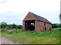
IF Barn
This dilapidated red brick barn is on a patch of land next to Court Farm House It has the word IF built into the brickwork above the front doors. It may have been to celebrate the poem by Kipling (1910) or it may be the initials of the owner or builder.
Image: © Nigel Mykura
Taken: 3 Jul 2011
0.00 miles
3
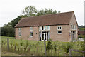
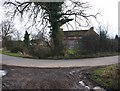
Court Farm House
This old farm house is on a very ancient site and it has two moats very close-by from previous dwellings.
Image: © Nigel Mykura
Taken: 3 Jul 2011
0.03 miles
5
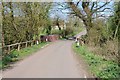
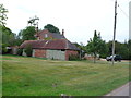
Bridge on a road to Sherbourne
Bridge on a road to Sherbourne near Court Farm House.
Image: © Philip Halling
Taken: 18 Apr 2018
0.06 miles
6
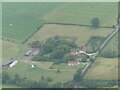
Two moated sites at Court Farm House, Fulbrook: aerial 2021
The monument survives well and remains largely unencumbered by modern development. It represents a good example of two moated sites constructed within close proximity to each other with valuable documentary information concerning their layout. Evidence for the design and function of the manor house which occupied the southern moated island and for structures which occupied the northern moated island will survive beneath the ground surface. Additionally organic material will be preserved within the waterfilled moat ditches of the southern moated site. The site retains well preserved remains of an extensive fishpond system, and the whole complex is set within units of ridge and furrow, the development of which will inform discussion of the date and character of occupation of the various parts of the site.
See https://historicengland.org.uk/listing/the-list/list-entry/1011196
Image: © Simon Tomson
Taken: 16 Aug 2021
0.08 miles
7
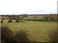
Fields by the River Avon
View NE across the Avon flood plain from the Hampton Lucy to Sherbourne lane. The spire of All Saints Church, Sherbourne can be seen in the distance.
Image: © David P Howard
Taken: 31 Jan 2010
0.22 miles
8
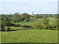
Distant view of All Saints Church, Sherbourne
Seen from near the middle of this square, with the course of the River Avon marked by the bushes as it meanders across the fields.
Image: © David Stowell
Taken: 28 May 2005
0.23 miles
9
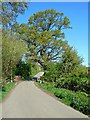
Cottage on bend in Fulbrook Lane, Sherbourne
Image: © David P Howard
Taken: 31 Jan 2010
0.23 miles
10
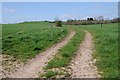
Track in a field near Sherbourne
Track in a field near Sherbourne, this is also the route of the Shakespeare's Avon Way long distance path.
Image: © Philip Halling
Taken: 18 Apr 2018
0.25 miles