IMAGES TAKEN NEAR TO
Wedgnock, WARWICK, CV35 7PY
Introduction
This page details the photographs taken nearby to CV35 7PY by members of the Geograph project.
The Geograph project started in 2005 with the aim of publishing, organising and preserving representative images for every square kilometre of Great Britain, Ireland and the Isle of Man.

There are currently over 7.5m images from over14,400 individuals and you can help contribute to the project by visiting https://www.geograph.org.uk
Image Map
Images are licensed for reuse under creativecommons.org/licenses/by-sa/2.0
Notes
- Clicking on the map will re-center to the selected point.
- The higher the marker number, the further away the image location is from the centre of the postcode.
Image Listing (8 Images Found)
Images are licensed for reuse under creativecommons.org/licenses/by-sa/2.0
Image
Details
Distance
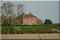
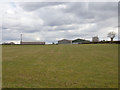
2
Deer Park Farm
Seen from the bridleway. Another bridleway once passed along the driveway and through the farmyard on its way to Bannerhill Farm but this has been diverted.
Image: © Michael Dibb
Taken: 1 Dec 2009
0.05 miles
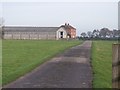
4
Parish boundary hedge north of Deer Park Farm
The boundary is between the parishes of Beausale to the east and Leek Wootton to the west.
The large barn recently built at Deer Park Farm Image is the fifth such.
Image: © Robin Stott
Taken: 17 Nov 2009
0.14 miles
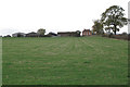
5
View towards Deer Park Farm
Looking ESE towards Deer Park Farm in Image from the bridleway to Bulloak Farm.
The bridleway has been diverted and is now some 100 metres north west of its marked position.
Image: © David P Howard
Taken: 13 Mar 2013
0.14 miles
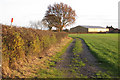
6
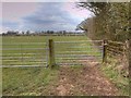
Diverted bridleway near Deer Park Farm
The top sign on the right hand gate post is a Warwickshire County Council sign that reads "Diverted Path".
The original route of the bridleway was parallel to this new route, about 100 metres to the south east, across the middle of the field. The new route now sensibly runs along the field margin.
Image: © David P Howard
Taken: 13 Mar 2013
0.21 miles
7
Private Road running past entrance to Deer Park Farm
Image: © AJD
Taken: Unknown
0.22 miles
8
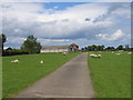
Deer Park Farm
The driveway to the farm in the middle distance. Until very recently this was also a public footpath but this has now been diverted alongside some adjacent fields.
Image: © David Stowell
Taken: 4 Jun 2005
0.23 miles