IMAGES TAKEN NEAR TO
Haseley, WARWICK, CV35 7LT
Introduction
This page details the photographs taken nearby to CV35 7LT by members of the Geograph project.
The Geograph project started in 2005 with the aim of publishing, organising and preserving representative images for every square kilometre of Great Britain, Ireland and the Isle of Man.

There are currently over 7.5m images from over14,400 individuals and you can help contribute to the project by visiting https://www.geograph.org.uk
Image Map
Images are licensed for reuse under creativecommons.org/licenses/by-sa/2.0
Notes
- Clicking on the map will re-center to the selected point.
- The higher the marker number, the further away the image location is from the centre of the postcode.
Image Listing (23 Images Found)
Images are licensed for reuse under creativecommons.org/licenses/by-sa/2.0
Image
Details
Distance
1
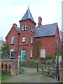
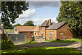
Firs Farm
This almost gothic victorian red brick house with its square tower and pyramid roof sits on the north side of the minor road running through Haseley Green. It has a prominent coat of arms above the door.
Image: © Nigel Mykura
Taken: 14 Apr 2012
0.01 miles
2
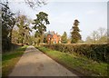
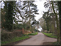
Haseley Green-Firs Farm
Approaching the farm on the single track road.
Image: © Ian Rob
Taken: 12 Mar 2016
0.01 miles
3
Victorian house, Haseley Green
A vaguely heraldic plaque on the turret bears the date 1864. Note: rush-infested foreground; ridge and furrow; the unusual grove of Scots pine and some old exotic conifers—origin of the name Firs Farm and Firs Lane?
Image: © Robin Stott
Taken: 27 Mar 2010
0.01 miles
4
Cycling through Haseley Green
The quiet lanes around Beausale and Haseley are popular with recreational cyclists. This pair is on Firs Lane where it passes between Firs Farm, off to the left, and the 1864 farmhouse, right.
Image: © Robin Stott
Taken: 1 Apr 2010
0.02 miles
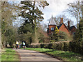
6
Firs Lane at Haseley Green
Image: © Robin Stott
Taken: 27 Mar 2010
0.06 miles
7
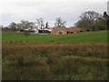
Firs Farm, Haseley Green
Seen from the southwest, near the Inchford Brook crossing. A broad expanse of rushy ground lies to the east of the brook upstream.
Image: © Robin Stott
Taken: 27 Mar 2010
0.06 miles
8
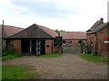
Haseley Green - Firs Farm
The farmyard - still very much a working dairy farm.
Image: © David Stowell
Taken: 31 May 2005
0.06 miles
9
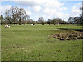
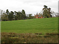
Field southeast of Firs Farm
Grassy platforms and hollows, both here and on the west side of Firs Lane, suggest that Haseley Green was once a much larger settlement but that the people and the houses have gone.
Image: © Robin Stott
Taken: 1 Apr 2010
0.06 miles
