IMAGES TAKEN NEAR TO
Sedgemoor Road, COVENTRY, CV3 4DZ
Introduction
This page details the photographs taken nearby to Sedgemoor Road, CV3 4DZ by members of the Geograph project.
The Geograph project started in 2005 with the aim of publishing, organising and preserving representative images for every square kilometre of Great Britain, Ireland and the Isle of Man.

There are currently over 7.5m images from over14,400 individuals and you can help contribute to the project by visiting https://www.geograph.org.uk
Image Map
Images are licensed for reuse under creativecommons.org/licenses/by-sa/2.0
Notes
- Clicking on the map will re-center to the selected point.
- The higher the marker number, the further away the image location is from the centre of the postcode.
Image Listing (47 Images Found)
Images are licensed for reuse under creativecommons.org/licenses/by-sa/2.0
Image
Details
Distance
1
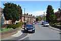
Sunnybank Avenue in the sun, Willenhall, southeast Coventry
Semi-detached houses, possibly flats, seen from the Southport Close turning. Sedgemoor Avenue and Sebastian Close are behind the camera. All the streetnames on this estate begin with S.
Image: © Robin Stott
Taken: 30 Apr 2016
0.04 miles
2
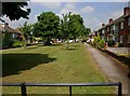
Green space between Sedgemoor Road and Sunnybank Avenue
A nice green space between the rows of houses. The council grass cutters were in the area, cutting and strimming, and had just done this patch.
Image: © David P Howard
Taken: 2 Jun 2010
0.07 miles
3
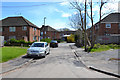
Southport Close, Willenhall, southeast Coventry
A cul-de-sac off Sunnybank Avenue with, behind the camera, a footbridge link over the River Sowe to the London Road Image The only properties in the Close are offstage left and right.
Image: © Robin Stott
Taken: 30 Apr 2016
0.08 miles
4
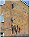
Satellite dishes, Southport Close, Willenhall, southeast Coventry
This suggests eight, perhaps nine flats in the block, T-shaped in plan.
Image: © Robin Stott
Taken: 30 Apr 2016
0.08 miles
5
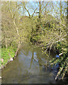
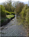
River Sowe upstream from the Southport Close footbridge, Willenhall, southeast Coventry
Hidden by trees is Willenhall Bridge, that carries the B4110 London Road from Whitley, left, up to the higher ground of Willenhall, right. The river is clear, sliding along briskly.
Image: © Robin Stott
Taken: 30 Apr 2016
0.10 miles
6
Footpath to Southport Close, Willenhall, southeast Coventry
The view is from the footbridge over the River Sowe Image
Image: © Robin Stott
Taken: 30 Apr 2016
0.10 miles
7
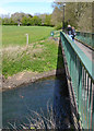
Footpath to London Road from Southport Close, Willenhall, southeast Coventry
Local people look at the River Sowe.
The reverse view is Image
The London Road end of the path is Image
A view of the playing field is Image
The view downstream is Image
Image: © Robin Stott
Taken: 30 Apr 2016
0.11 miles
8
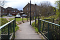
Footbridge over the River Sowe to Southport Close, Willenhall, southeast Coventry
Southport Close is a cul-de-sac off the Sunnybank Avenue-Sedgemoor Road loop (on this estate, all the streetnames start with S).
Image: © Robin Stott
Taken: 30 Apr 2016
0.11 miles
9
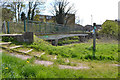
River Sowe downstream from Southport Close, Willenhall, southeast Coventry
The water is clear, burbling along in businesslike fashion. The view is from the footbridge Image
Image: © Robin Stott
Taken: 30 Apr 2016
0.11 miles
10
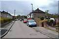
Sebastian Close, Willenhall, southeast Coventry
A later walk made it clear that this is made-up, level ground. Hard-to-find footpaths off this close and Sedgemoor Road drop sharply down to a grassy open space in the floodplain of the River Sowe.
Image: © Robin Stott
Taken: 30 Apr 2016
0.12 miles