IMAGES TAKEN NEAR TO
Friars Street, WARWICK, CV34 6HA
Introduction
This page details the photographs taken nearby to Friars Street, CV34 6HA by members of the Geograph project.
The Geograph project started in 2005 with the aim of publishing, organising and preserving representative images for every square kilometre of Great Britain, Ireland and the Isle of Man.

There are currently over 7.5m images from over14,400 individuals and you can help contribute to the project by visiting https://www.geograph.org.uk
Image Map
Images are licensed for reuse under creativecommons.org/licenses/by-sa/2.0
Notes
- Clicking on the map will re-center to the selected point.
- The higher the marker number, the further away the image location is from the centre of the postcode.
Image Listing (879 Images Found)
Images are licensed for reuse under creativecommons.org/licenses/by-sa/2.0
Image
Details
Distance
1
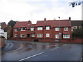
The Guild Cottages
This modern almshouse development was funded by a charity which setup at the time of the dissolution of the Guilds under Henry VIII. One Thomas Oaken was a local benefactor who was behind transferring the assets of the Guilds to the local corporation and charitable funds before they could be seized by the crown. Image can still be seen in Castle Street.
A Image commemorates the construction.
Image: © David Stowell
Taken: 6 Oct 2006
0.02 miles
2
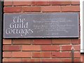
Plaque on The Guild Cottages
A close up of the commemorative plaque on Image
Image: © David Stowell
Taken: 6 Oct 2006
0.02 miles
3
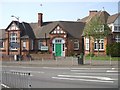
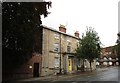
Westgate Primary School, Warwick
A finely preserved building.
Image: © Kenneth Allen
Taken: 14 Apr 2007
0.02 miles
5
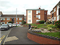
Flats and front gardens, Abbots Way, Warwick
Image: © Robin Stott
Taken: 20 Sep 2013
0.02 miles
6
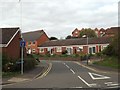
Westgate Close, Warwick
These are characteristic old people's bungalows, built by or for Warwick District Council. The viewpoint is the footpath that emerges from Abbots Way on to Friars Street opposite the close. High on the right is the housing at Martinique Square Image
Image: © Robin Stott
Taken: 20 Sep 2013
0.03 miles
7
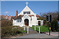
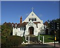
New Life Church
The New Life Church on Hampton Street in Warwick. The tablet in the gable is inscribed '1893', presumably when the church was built.
Image: © Philip Halling
Taken: 18 Apr 2018
0.03 miles
8
Moss House, West Street, Warwick
A former Vicarage https://historicengland.org.uk/listing/the-list/list-entry/1035386
Image: © Jonathan Thacker
Taken: 29 Sep 2019
0.03 miles
9
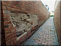
Northwest on an unnamed passage between West Street and Abbots Way, Warwick
Preserved and pointed masonry is exposed in the brick wall on the left. Brick paving is unusual in Warwick: a survival, perhaps
Image: © Robin Stott
Taken: 20 Sep 2013
0.04 miles
10
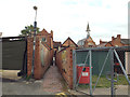
Unnamed passage from Abbots Way to West Street, Warwick
Right of centre is the spirelet of St Mary Immaculate Church, West Street.
Image: © Robin Stott
Taken: 20 Sep 2013
0.04 miles