IMAGES TAKEN NEAR TO
St. Michaels Road, WARWICK, CV34 5RS
Introduction
This page details the photographs taken nearby to St. Michaels Road, CV34 5RS by members of the Geograph project.
The Geograph project started in 2005 with the aim of publishing, organising and preserving representative images for every square kilometre of Great Britain, Ireland and the Isle of Man.

There are currently over 7.5m images from over14,400 individuals and you can help contribute to the project by visiting https://www.geograph.org.uk
Image Map
Images are licensed for reuse under creativecommons.org/licenses/by-sa/2.0
Notes
- Clicking on the map will re-center to the selected point.
- The higher the marker number, the further away the image location is from the centre of the postcode.
Image Listing (130 Images Found)
Images are licensed for reuse under creativecommons.org/licenses/by-sa/2.0
Image
Details
Distance
1
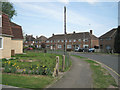
The bend in St Michael's Road
A former council housing estate.
Image: © Robin Stott
Taken: 9 Apr 2011
0.02 miles
2
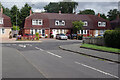
St Christopher's Close and St Michael's Road, Warwick
Looking along St Christopher's Close to its junction with St Michael's Road. The houses are of an unusual style, with seemingly over-large roofs.
Image: © Stephen McKay
Taken: 11 Aug 2021
0.05 miles
3
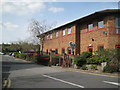
Entrance, St Michael's Hospital
When Central Hospital, Hatton (the county mental hospital) was eventually disposed of for residential development, those patients who could not be safely released into the community were transferred to the secure St Michael's Hospital, built for the purpose in St Michael's Road.
Image: © Robin Stott
Taken: 9 Apr 2011
0.05 miles
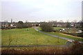
4
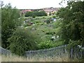
Cape Road allotments, Warwick
Seen from the railway bridge.
Image: © Robin Stott
Taken: 13 Jul 2009
0.08 miles
5
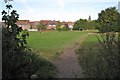
St Michael's open space, Warwick
Once part of Warwick's commonable lands known as the Pigwells. Railway is behind the viewpoint. Allotments to the right. Roofs of secure mental hospital showing above the houses.
Image: © Robin Stott
Taken: 4 Oct 2009
0.08 miles
7
Footpath to Cape Road
It runs northeast from St Michael's Road.
Image: © Robin Stott
Taken: 9 Apr 2011
0.08 miles
8
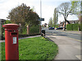
Corner of St Michael's Road and Cape Road
Looking towards the junction with Millers Road and the Jolly Miller pub on the corner. Postbox number CV34 124.
Image: © Robin Stott
Taken: 9 Apr 2011
0.09 miles
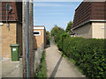
9
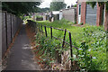
Path to St Michael's Road, Warwick
This path provides a convenient pedestrian route connecting Cape Road with St Michael's Road in the Cape area of Warwick. St Michael's Hospital is behind the fence on the left.
Image: © Stephen McKay
Taken: 11 Aug 2021
0.10 miles
10
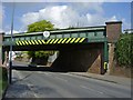
Warwick-Birmingham Road
The line to Birmingham crosses at this point.
Image: © Ian Rob
Taken: 16 Apr 2011
0.11 miles