IMAGES TAKEN NEAR TO
Deerpark Drive, WARWICK, CV34 5ED
Introduction
This page details the photographs taken nearby to Deerpark Drive, CV34 5ED by members of the Geograph project.
The Geograph project started in 2005 with the aim of publishing, organising and preserving representative images for every square kilometre of Great Britain, Ireland and the Isle of Man.

There are currently over 7.5m images from over14,400 individuals and you can help contribute to the project by visiting https://www.geograph.org.uk
Image Map
Images are licensed for reuse under creativecommons.org/licenses/by-sa/2.0
Notes
- Clicking on the map will re-center to the selected point.
- The higher the marker number, the further away the image location is from the centre of the postcode.
Image Listing (145 Images Found)
Images are licensed for reuse under creativecommons.org/licenses/by-sa/2.0
Image
Details
Distance
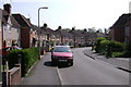
2
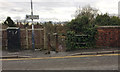
Newburgh Crescent, The Cape, Warwick
These houses, along with those in Deerpark Drive, Wedgnock Green and Oken Road, appear on an OS map of 1925. The estate would be the first 20th-century residential development in the Cape area. Deerpark Drive curves off immediately past the trees. To the right of the camera are some lock-up garages.
Image: © Robin Stott
Taken: 30 Jul 2017
0.03 miles
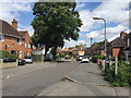
3
Cape Road crosses the railway, Warwick
Long shadows accompany a lockdown walk. St Mary's church tower is on the skyline.
Image: © Robin Stott
Taken: 10 Feb 2021
0.04 miles
4
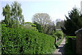
Footpath through allotments, rear of Newburgh Crescent, Warwick
Runs from Newburgh Crescent to join the long footpath on the north side of the railway, between Coventry Road and Cape Road.
Image: © Robin Stott
Taken: 20 Apr 2009
0.05 miles
5
Street furniture and sign by Cape Road, Warwick
This is on the north side of the bridge, right, that takes Cape Road over the railway. The cabinet can only be for street lighting. The arrow on the sign is pointing the wrong way. Perhaps it should have been erected on the opposite side of the road, behind the camera. Some premises in Cattell Road are seen in Image Two slim cast-iron bollards guard the top of a steep flight of 26 steps down to a footpath by the railway. Distant trees are in Priory Park.
Image: © Robin Stott
Taken: 1 Feb 2017
0.05 miles
6
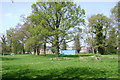
Priory Pools, Warwick
This greenspace was once part of the grounds of Priory House until they were severed by the Great Western Railway.
The pools have long been filled in but some slender alder trees remain. Council flats in Lyttleton Road to the north.
Allotments out of shot left. St Mary's primary school out of shot, right. Railway behind the viewpoint.
Image: © Robin Stott
Taken: 20 Apr 2009
0.06 miles
7
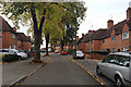
Deerpark Drive, Packmores estate, north Warwick
This council housing first appears in outline on a map of 1938. Looking north towards Wedgnock Green.
Image: © Robin Stott
Taken: 30 Oct 2019
0.06 miles
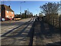
8
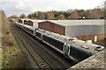
A four-coach Chiltern Railways service heading north from Warwick
Before the pandemic most Chiltern diesel multiple unit services were of three coaches. To make some allowance for social distancing on board, most trains have been extended to four coaches by breaking up train sets and reforming them; a few two-coach trains are running. The view is from the Cape Road bridge. In the background are Cattell Road businesses, Spring Pool housing, and Priory Park.
Image: © Robin Stott
Taken: 9 Feb 2021
0.06 miles
9
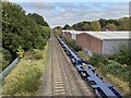
Long tail, northbound container freight, Warwick
This train came through in mid-afternoon on a Thursday. At its head were 6-7 wagons carrying one full-size container and 11-12 'small' boxes. Following them were 19 empty wagons, some of them looking brand new, representing capacity for 19 full-size containers.
Two or three weeks later, from observation, trains are carrying more boxes in each direction. Christmas imports are on the move: perhaps southbound trains are hauling mostly empties.
Image: © Robin Stott
Taken: 28 Oct 2021
0.06 miles
10
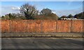
Parapet, Cape Road bridge, Warwick
While I was waiting to photograph a container freight train, the sun came out revealing a ghost sign on the rusting iron plates of the parapet. It reads:
HORSEHAY Co LTD
MAKERS
SHROPSHIRE
Horsehay Ironworks (1755-1984) was established north of Coalbrookdale by Abraham Darby II. By 1790 it was operating one of the first rolling mills. Horsehay became famous for constructing iron bridges and cranes http://www.dawleyheritage.co.uk/timeline/56/horsehay-ironworks-opened Brunel's Oxford to Birmingham Railway extension opened in 1852. There's every reason to believe that this is an original bridge. There is a narrow footway on each side, presumably added later, obscuring the lower part of 'Shropshire'.
Image: © Robin Stott
Taken: 9 Feb 2021
0.06 miles