IMAGES TAKEN NEAR TO
Oken Road, WARWICK, CV34 5EA
Introduction
This page details the photographs taken nearby to Oken Road, CV34 5EA by members of the Geograph project.
The Geograph project started in 2005 with the aim of publishing, organising and preserving representative images for every square kilometre of Great Britain, Ireland and the Isle of Man.

There are currently over 7.5m images from over14,400 individuals and you can help contribute to the project by visiting https://www.geograph.org.uk
Image Map
Images are licensed for reuse under creativecommons.org/licenses/by-sa/2.0
Notes
- Clicking on the map will re-center to the selected point.
- The higher the marker number, the further away the image location is from the centre of the postcode.
Image Listing (133 Images Found)
Images are licensed for reuse under creativecommons.org/licenses/by-sa/2.0
Image
Details
Distance
1
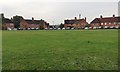
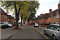
Wedgnock Green, north Warwick
The estate, mostly complete, first appears on an OS map of 1925, a council estate implanted into farmland on the northwest edge of the town. The principal access was from Cape Road; a secondary access was from Millers Lane, the future Millers Road. The latter was extended east by 1938 but not connected to Lakin Road and Coventry Road until about 1970.
Image: © Robin Stott
Taken: 30 Oct 2019
0.05 miles
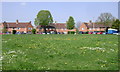
3
Wedgnock Green, Packmores estate, north Warwick
This council housing first appears in outline on a map of 1938.
Image: © Robin Stott
Taken: 30 Oct 2019
0.06 miles
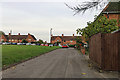
4
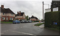
Corner of St Michael's Road and Cape Road
Looking towards the junction with Millers Road and the Jolly Miller pub on the corner. Postbox number CV34 124.
Image: © Robin Stott
Taken: 9 Apr 2011
0.06 miles
5
Deerpark Drive, Packmores estate, north Warwick
This council housing first appears in outline on a map of 1938. Looking north towards Wedgnock Green.
Image: © Robin Stott
Taken: 30 Oct 2019
0.07 miles
6
Houses on Millers Road from the top of Lock Lane, The Cape, Warwick
Millers Road serves housing, industry, retail and hospitals. Cape locks were the Warwick end of the Warwick and Napton Canal, which opened in March 1800. Together with the Warwick and Birmingham Canal it formed part of a planned through route between Birmingham and London that later became the Grand Union Canal.
Image: © Robin Stott
Taken: 29 Mar 2017
0.07 miles
7
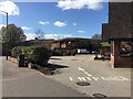
Entrance to foodstore, Millers Road, Warwick
The former 'Jolly Miller' public house Image has become a Mid-Counties Co-op convenience store. In the background across Cape Road is St Michael's secure mental hospital.
Image: © Robin Stott
Taken: 25 Mar 2019
0.07 miles
8
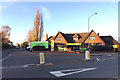
Midcounties Co-operative food store in the former Jolly Miller pub, Cape Road, Warwick
Another local pub finding new life as a convenience store. It's on the corner of Cape Road, left, and Millers Road, foreground, a prime site in an area of mixed use: residential, businesses and two hospitals, with canal moorings at the Cape. I last saw this pub boarded up and before that, closed. It was looking quiet when Julian Osley photographed it in 2013 Image The go-ahead Midcounties Co-operative Society is one of two Co-ops serving Warwick and Leamington, the other being the Heart of England Co-operative Society – who don't accept the Co-operative member's card. When is the Co-op not the Co-op?
Image: © Robin Stott
Taken: 26 Nov 2016
0.08 miles
9
Customer Information, Co-operative Food store, Millers Road, Warwick
On this occasion, in the chaotic early phase of Covid-19 lockdown, there was no queuing; physical distancing was near-impossible in a cramped shop; no-one wore a face mask; checkout assistants had no protection; payment by card, preferably contactless, was preferred. Sale of some items was restricted to one per customer. The store, a favourite, is close to two hospitals Image and back at home I became anxious that I had put myself at risk.
Image: © Robin Stott
Taken: 28 Mar 2020
0.08 miles
10
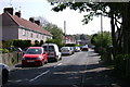
Lyttleton Road, Warwick
The blocks of flats at the end of the road are seen from the other side in Image
Image: © Robin Stott
Taken: 20 Apr 2009
0.08 miles