IMAGES TAKEN NEAR TO
Packmore Street, WARWICK, CV34 5BX
Introduction
This page details the photographs taken nearby to Packmore Street, CV34 5BX by members of the Geograph project.
The Geograph project started in 2005 with the aim of publishing, organising and preserving representative images for every square kilometre of Great Britain, Ireland and the Isle of Man.

There are currently over 7.5m images from over14,400 individuals and you can help contribute to the project by visiting https://www.geograph.org.uk
Image Map
Images are licensed for reuse under creativecommons.org/licenses/by-sa/2.0
Notes
- Clicking on the map will re-center to the selected point.
- The higher the marker number, the further away the image location is from the centre of the postcode.
Image Listing (346 Images Found)
Images are licensed for reuse under creativecommons.org/licenses/by-sa/2.0
Image
Details
Distance
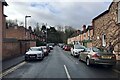
1
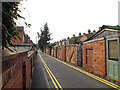
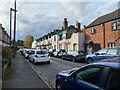
Packmore Street, Warwick, looking west
An odd street with house frontages on the south side and the rear garden boundaries of Paradise Street on the north side.
Image: © Robin Stott
Taken: 28 Aug 2013
0.01 miles
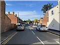
2
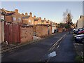
East on Packmore Street, Warwick
Packmore Street is a narrow one-way residential road, unusual in that houses on the south side, right, face the street while the north side presents the rear of properties in Paradise Street.
Image: © Robin Stott
Taken: 30 Nov 2019
0.02 miles
3
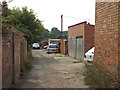
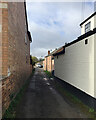
Rear access to Woodcote Road and Packmore Street, Warwick
From conversation with a local resident it appeared that this rear way was one of the many that have not been adopted by the local highway authority. The individual property boundaries extend to the centre of the space and each owner is responsible for the maintenance of their part of it.
Image: © Robin Stott
Taken: 28 Aug 2013
0.02 miles
4
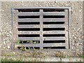
Gully grating, rear of Packmore Street, Warwick
In the unadopted rear access in Image Cast-iron or possibly ductile steel, given the tensions that must be generated by the load of a vehicle passing over it. Roberts, Warwick – I don't know if this was a past local ironmongery supplier or whether it is the name of a long-gone local foundry. Maps of the 1880s show two foundries in the immediate area. There will be clues in old trade directories.
Image: © Robin Stott
Taken: 28 Aug 2013
0.02 miles
5
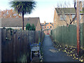
Rear access off Lakin Road, Warwick
To the left is No 25 Lakin Road; to the right is the Wild Boar Inn.
Image: © Robin Stott
Taken: 3 Mar 2020
0.03 miles
6
Footpath to Packmore Street, Warwick
Behind the camera is the broad path that runs on the north side of the railway, west from the station towards Priory Pools.
Image: © Robin Stott
Taken: 30 Nov 2019
0.03 miles
7
Building project, Paradise Street, Warwick
Image: © Robin Stott
Taken: 28 Oct 2021
0.03 miles
8
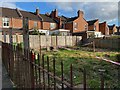
Marked out ? plot by Paradise Street, Warwick
It could just be a garden but there's room for a house.
Image: © Robin Stott
Taken: 28 Oct 2021
0.04 miles
10
Woodcote Road, Packmores, Warwick
A neat residential street off Lakin Road. It leads to the rear entrance to Warwick station, which is up on a tree-clad embankment.
Image: © Robin Stott
Taken: 3 Mar 2020
0.04 miles