IMAGES TAKEN NEAR TO
Coach House Mews, Coventry Road, WARWICK, CV34 4LD
Introduction
This page details the photographs taken nearby to Coach House Mews, Coventry Road, CV34 4LD by members of the Geograph project.
The Geograph project started in 2005 with the aim of publishing, organising and preserving representative images for every square kilometre of Great Britain, Ireland and the Isle of Man.

There are currently over 7.5m images from over14,400 individuals and you can help contribute to the project by visiting https://www.geograph.org.uk
Image Map
Images are licensed for reuse under creativecommons.org/licenses/by-sa/2.0
Notes
- Clicking on the map will re-center to the selected point.
- The higher the marker number, the further away the image location is from the centre of the postcode.
Image Listing (628 Images Found)
Images are licensed for reuse under creativecommons.org/licenses/by-sa/2.0
Image
Details
Distance
1
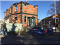
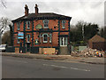
The burnt-out Great Western pub, Coventry Road, Warwick
At the corner of Station Road, foreground.
Image: © Robin Stott
Taken: 8 Nov 2017
0.02 miles
2
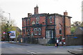
Great Western, Warwick
A former pub awaiting demolition following a damaging fire.
Image: © Bill Boaden
Taken: 19 Apr 2019
0.02 miles
3
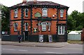
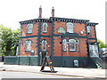
The former Great Western (1), Coventry Road, Warwick
This Victorian public house, originally known as the Great Western Hotel, dated back to at least 1862. It seems to have closed shortly after this photograph was taken in July 2015. Planning permission was obtained for conversion to flats but before work commenced it was badly damaged in a fire, believed to be arson, in August 2017. Sadly the building was demolished in November 2019 and the site will be used for housing.
Image
Image
Image: © P L Chadwick
Taken: 27 Jul 2015
0.02 miles
4
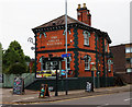
The former Great Western (2), Coventry Road, Warwick
Sadly this attractive Victorian public house was demolished in November 2019 after it was badly damaged in an arson attack in August 2017. It is believed to have closed shortly after this photograph was taken in July 2015. It was located on the corner of Station Road and Coventry Road.
See also:- Image; Image
Image: © P L Chadwick
Taken: 27 Jul 2015
0.02 miles
5
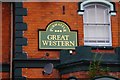
The former Great Western (3) - sign, Coventry Road, Warwick
The sign of the former Great Western public house, on the side of the building facing Coventry Road. The building was demolished in November 2019. It was for a while part of the large Pubmaster estate of pubs.
Photographs of the pub taken in July 2015:- Image; Image
Image: © P L Chadwick
Taken: 27 Jul 2015
0.02 miles
6
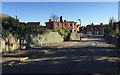
Corner of Station Road and Coventry Road, Warwick
The wreck of the burnt-out Great Western pub is slowly deteriorating. Last photographed in November: Image Baxi's premises extend behind it on both sides, obscuring Warwick station.
Image: © Robin Stott
Taken: 15 Dec 2017
0.02 miles
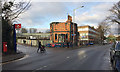
8
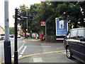
Junction of Station Road and Coventry Road, Warwick
The Great Western pub is immediately behind the camera Image Postbox number CV34 125.
Image: © Robin Stott
Taken: 28 Aug 2013
0.02 miles
9
The former Great Western public house, Coventry Road, Warwick
This handsome and much-photographed pub has closed and is being gutted by the looks of it while under offer. It stands prominently on the corner of Coventry Road and Station Road: see Image from 2015.
Update
The Stratford Herald's free Midweek edition reported that the pub had partially collapsed during a devastating fire on the afternoon of Thursday 24 August 2017. "It was really quick, the whole place went up in about 20 minutes" said the landlord of the Railway Inn across the road Image The fire is being treated as suspicious.
Image: © Robin Stott
Taken: 26 Feb 2017
0.02 miles
10
Station Road and the remains of the Great Western pub, Warwick
Previously recorded in February 2017 the gutted building (Image) was rapidly consumed by a fire in August. This photo is 8 November 2017. The shell was still in this state in late December. The houses are in Coventry Road.
Image: © Robin Stott
Taken: 8 Nov 2017
0.02 miles