IMAGES TAKEN NEAR TO
Windermere Avenue, COVENTRY, CV3 2DJ
Introduction
This page details the photographs taken nearby to Windermere Avenue, CV3 2DJ by members of the Geograph project.
The Geograph project started in 2005 with the aim of publishing, organising and preserving representative images for every square kilometre of Great Britain, Ireland and the Isle of Man.

There are currently over 7.5m images from over14,400 individuals and you can help contribute to the project by visiting https://www.geograph.org.uk
Image Map
Images are licensed for reuse under creativecommons.org/licenses/by-sa/2.0
Notes
- Clicking on the map will re-center to the selected point.
- The higher the marker number, the further away the image location is from the centre of the postcode.
Image Listing (19 Images Found)
Images are licensed for reuse under creativecommons.org/licenses/by-sa/2.0
Image
Details
Distance
1
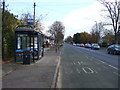
Bus stop and shelter on Binley Road (A428)
Looking east.
Image: © JThomas
Taken: 19 Nov 2016
0.11 miles
3
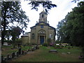
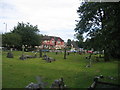
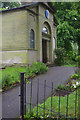
St Bartholomew's, Binley
This church is one of the older buildings in this square and, although close to the main roads, is partially screened by trees and not easily overlooked.
Image: © David Stowell
Taken: 5 Aug 2005
0.14 miles
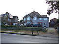
4
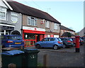
Binley Post Office
On Binley Road.
Showing position of Postbox No. CV3 95.
See Image] for postbox.
Image: © JThomas
Taken: 19 Nov 2016
0.15 miles
5
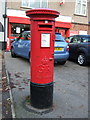
George V postbox, Binley Post Office
Postbox No. CV3 95.
See Image] for context.
Image: © JThomas
Taken: 19 Nov 2016
0.16 miles
6
Craven Arms, Binley
Looking across to the busy road junction in front of the pub from the churchyard of St Bartholomew's.
Image: © David Stowell
Taken: 5 Aug 2005
0.20 miles
7
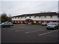
Binley Travelodge,Brandon road
Situated behind the Toby Inn.
Image: © Anthony Vosper
Taken: 17 Feb 2012
0.22 miles
8
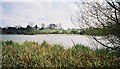
Stoke Floods looking towards Binley church and vicarage
Stoke Floods is a nature reserve comprising a pool surrounded by reedbeds and scrub. The pool is a flash, a body of water occupying land that has subsided, in this case as a result of mine-workings at Binley Colliery.
Image: © A J Paxton
Taken: Unknown
0.22 miles
9
St Bartholomew's Church, Binley
This small church, now surrounded by the Coventry suburbs, dates from the 1770s when it was built by Lord Craven. There had been a church here previously, in medieval times known as St Swithin's.
Image: © Stephen McKay
Taken: 28 May 2014
0.23 miles
10
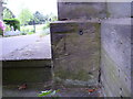
Benchmark on Binley Church
This benchmark was established in 1856 during the First primary levelling of England & Wales, and was levelled with a height of 271.0880 feet [82.6276 metres] above mean sea level (Liverpool datum). It was included on the Coventry to Lincoln levelling line. The surveyor's description was "No. 6. Bolt in South side of door, in West front of Binley Church ; 1.49 ft. above surface" (Public Abstract p.326). It is on the south face of the column to the south of the doorway, behind a shrub.
Image: © Shantavira
Taken: 23 May 2015
0.23 miles