IMAGES TAKEN NEAR TO
Percy Terrace, LEAMINGTON SPA, CV32 5PG
Introduction
This page details the photographs taken nearby to Percy Terrace, CV32 5PG by members of the Geograph project.
The Geograph project started in 2005 with the aim of publishing, organising and preserving representative images for every square kilometre of Great Britain, Ireland and the Isle of Man.

There are currently over 7.5m images from over14,400 individuals and you can help contribute to the project by visiting https://www.geograph.org.uk
Image Map
Images are licensed for reuse under creativecommons.org/licenses/by-sa/2.0
Notes
- Clicking on the map will re-center to the selected point.
- The higher the marker number, the further away the image location is from the centre of the postcode.
Image Listing (194 Images Found)
Images are licensed for reuse under creativecommons.org/licenses/by-sa/2.0
Image
Details
Distance
1
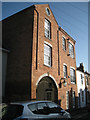
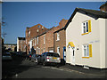
Gunnery House, Gunnery Terrace
This old works or warehouse towers over the modest two-storey terraced cottages in the street. It has been converted to residential use. A keystone introduced into the brick arch has been inscribed '1859 VR'. The etched glass in the pendant lantern shows the letters 'GH' but it may be modern. Image is a view of the street.
Image: © Robin Stott
Taken: 15 Jan 2012
0.02 miles
2
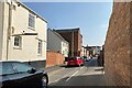
Gunnery Terrace, Leamington
The name remembers Gunnery Farm. Recollections published in 1895 recall the area as open fields until 1833 when Gunnery-row was built, reportedly in parallel Guy's Cliffe Road. The tall brick building is Gunnery House, built 1850, restored in 1990, and now occupied by several companies; not listed.
Image: © Robin Stott
Taken: 23 Mar 2022
0.02 miles
3
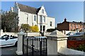
North end of Percy Terrace, Leamington
The road name remembers the Percy family, who became associated with the Guy's Cliffe estate through marriage. The view is from Rugby Road.
Image: © Robin Stott
Taken: 23 Mar 2022
0.02 miles
4
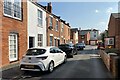
Terraced houses, Gunnery Terrace, Leamington
The name remembers Gunnery Farm.
Image: © Robin Stott
Taken: 23 Mar 2022
0.02 miles
5
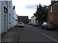
Gunnery Terrace
A short residential street seen here from the bend of Cross Road. In the distance, left, is the 20th-century 3-storey terrace of Cornwall Place, known to many as Rugby Road shops. The name Gunnery recalls Gunnery Farm on the Guy's Cliffe estate, long built over. The huge map of the 1805 Milverton inclosure award (which preceded any development) names it as Conery Farm.
Image: © Robin Stott
Taken: 15 Jan 2012
0.03 miles
6
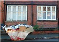
Level Loads Only
To minimise costs the builder only bought a very small skip (4 cu. yds) and consequently the load is excessive. It is outside a row of substantial terraced houses on the Rugby Road.
Image: © Nigel Mykura
Taken: 2 Jan 2012
0.04 miles
8
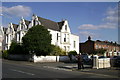
Corner of Rugby Road and Percy Terrace
Another Leamingtonian contrast of house sizes and styles.
Image: © Robin Stott
Taken: 29 Mar 2009
0.04 miles
9
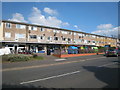
Cornwall Place shops
This 1960s style development of shops with flats above is situated beside the Rugby Road and provides facilities for the local community.
Image: © David Stowell
Taken: 1 Apr 2009
0.04 miles
10
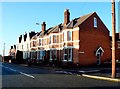
Houses on the Rugby Rd
These red brick Victorian terraced houses are on the Rugby road out of Warwick which would have originally run across the north of Leamington Spa and then through Weston under Wetherly and Princethorpe to Rugby. The road off on the right is Cornwall Place.
Image: © Nigel Mykura
Taken: 2 Jan 2012
0.05 miles