IMAGES TAKEN NEAR TO
Second Avenue, COVENTRY, CV3 1QQ
Introduction
This page details the photographs taken nearby to Second Avenue, CV3 1QQ by members of the Geograph project.
The Geograph project started in 2005 with the aim of publishing, organising and preserving representative images for every square kilometre of Great Britain, Ireland and the Isle of Man.

There are currently over 7.5m images from over14,400 individuals and you can help contribute to the project by visiting https://www.geograph.org.uk
Image Map
Images are licensed for reuse under creativecommons.org/licenses/by-sa/2.0
Notes
- Clicking on the map will re-center to the selected point.
- The higher the marker number, the further away the image location is from the centre of the postcode.
Image Listing (7 Images Found)
Images are licensed for reuse under creativecommons.org/licenses/by-sa/2.0
Image
Details
Distance
1
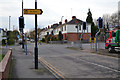
Pointing to The Spires: junction of Second Avenue and Weir Way, Stoke, Coventry
Weir Way or Brindle Avenue? Maps disagree. The Spires is a housing development by Morris Homes on the Marconi site.
Image: © Robin Stott
Taken: 21 Nov 2015
0.09 miles
2
Looking west on Gwendolyn Drive, The Spires development, Stoke, Coventry
A residential development by Morris Homes on the site of the Marconi works. The derelict Copsewood Grange is behind the camera: Image
Image: © Robin Stott
Taken: 21 Nov 2015
0.15 miles
3
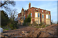
Derelict Copsewood Grange east of the Marconi site, Stoke, Coventry
The Spires, a residential development by Morris Homes, is taking shape around it. It was built in 1872, on the site of the plain, two-storey Copsewood House. It was home to the Moon family, perhaps from 1814. The 4th Baronet Moon died in 1979. An old OS map of 1925 shows the new Peel-Conner telephone works, later GEC, later Marconi, to the west of the house, and a golf course to the east running down to the River Sowe below Binley Bridge. Allard Way, first shown on a map of 1992, severed the golf course, which has transferred to land east of the river. My understanding is that Copsewood Grange became the social centre for Marconi's workers. It sits among some very fine mature specimen trees. At the time of writing, 2016, Kevin Croucher's 2005 photo and description Image is our only record of this major industrial site.
Sources: old-maps.co.uk and David McGrory: The Illustrated History of Coventry's Suburbs: Breedon Books, 2003, ISBN 1 85983 343 8
Image: © Robin Stott
Taken: 21 Nov 2015
0.16 miles
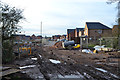
4
Marconi - New Century Park
Manufacturer of telecom equipment, formerly the GEC Telephone Works. Sadly a shadow of its former self after years of cutbacks, the result of technology change, the 1990s telecom boom and bust and more recently, foreign competition.
Update September 2010: All but one of the buildings on this site were demolished in 2010 to make way for a residential development.
Image: © Kevin Croucher
Taken: 14 Jun 2005
0.16 miles
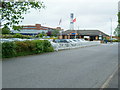
5
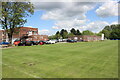
Buildings at Copsewood Grange Golf Club
As well as the golf clubhouse there are facilities for bowling and tennis at the club.
Image: © Nigel Mykura
Taken: 15 May 2023
0.16 miles
6
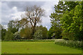
Trees by the River Sowe, Binley, east Coventry
The Sowe Valley footpath follows the river at the edge of extensive school playing fields, bright green and flat. There are private sports grounds to the north, behind all these trees. Left of centre a colossal Balsam Poplar is unfolding its new leaves, coppery and scented.
Image: © Robin Stott
Taken: 22 May 2016
0.22 miles
7
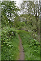
Sowe Valley footpath enters the Binley side of the valley, east Coventry
This scene is only a little further on from Image There is traffic noise from Allard Way, out of sight left.
Image: © Robin Stott
Taken: 22 May 2016
0.23 miles