Derelict Copsewood Grange east of the Marconi site, Stoke, Coventry
Introduction
The photograph on this page of Derelict Copsewood Grange east of the Marconi site, Stoke, Coventry by Robin Stott as part of the Geograph project.
The Geograph project started in 2005 with the aim of publishing, organising and preserving representative images for every square kilometre of Great Britain, Ireland and the Isle of Man.

There are currently over 7.5m images from over 14,400 individuals and you can help contribute to the project by visiting https://www.geograph.org.uk
Derelict Copsewood Grange east of the Marconi site, Stoke, Coventry
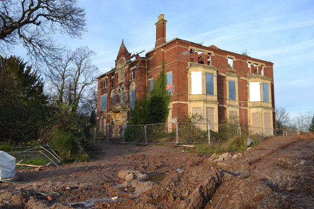
Image: © Robin Stott Taken: 21 Nov 2015
The Spires, a residential development by Morris Homes, is taking shape around it. It was built in 1872, on the site of the plain, two-storey Copsewood House. It was home to the Moon family, perhaps from 1814. The 4th Baronet Moon died in 1979. An old OS map of 1925 shows the new Peel-Conner telephone works, later GEC, later Marconi, to the west of the house, and a golf course to the east running down to the River Sowe below Binley Bridge. Allard Way, first shown on a map of 1992, severed the golf course, which has transferred to land east of the river. My understanding is that Copsewood Grange became the social centre for Marconi's workers. It sits among some very fine mature specimen trees. At the time of writing, 2016, Kevin Croucher's 2005 photo and description Image is our only record of this major industrial site. Sources: old-maps.co.uk and David McGrory: The Illustrated History of Coventry's Suburbs: Breedon Books, 2003, ISBN 1 85983 343 8
Images are licensed for reuse under creativecommons.org/licenses/by-sa/2.0
Image Location
Latitude
52.403654
Longitude
-1.463893