IMAGES TAKEN NEAR TO
Ribble Road, COVENTRY, CV3 1AU
Introduction
This page details the photographs taken nearby to Ribble Road, CV3 1AU by members of the Geograph project.
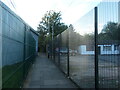
The Geograph project started in 2005 with the aim of publishing, organising and preserving representative images for every square kilometre of Great Britain, Ireland and the Isle of Man.

There are currently over 7.5m images from over14,400 individuals and you can help contribute to the project by visiting https://www.geograph.org.uk
Image Map
Images are licensed for reuse under creativecommons.org/licenses/by-sa/2.0
Notes
- Clicking on the map will re-center to the selected point.
- The higher the marker number, the further away the image location is from the centre of the postcode.
Image Listing (39 Images Found)
Images are licensed for reuse under creativecommons.org/licenses/by-sa/2.0
Image
Details
Distance
1
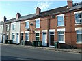
8 - 12 Humber Avenue, Coventry
Built between 1903 and 1912.
Image: © Christine Johnstone
Taken: 24 Sep 2021
0.05 miles
2
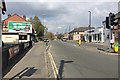
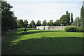
North end of Humber Road, Lower Stoke, Coventry
The open spaces ahead are Gosford Green on the left and Stoke Park on the right.
Image: © Robin Stott
Taken: 13 Apr 2019
0.06 miles
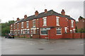
3
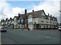
Coventry-Humber Road
The Humber Public House.
Image: © Ian Rob
Taken: 14 Apr 2008
0.08 miles
4
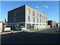
Signature Studio Living, Bilton industrial estate, Coventry
Either a converted office block, or on the site of one?
Image: © Christine Johnstone
Taken: 24 Sep 2021
0.08 miles
5
Footpath between the two halves of Humber Avenue
Once a footbridge over a railway line, but both have now gone.
Image: © Christine Johnstone
Taken: 24 Sep 2021
0.08 miles
6
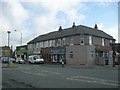
Coventry-Lower Stoke
Shops and houses on Humber Road.
Image: © Ian Rob
Taken: 14 Apr 2008
0.10 miles
7
Houses on Humber Avenue at St George's Road junction
There is an Ordnance Survey benchmark Image on the right hand face of the nearest house at the junction with its angled face
Image: © Roger Templeman
Taken: 8 Aug 2017
0.10 miles
8
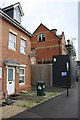
#104 and development site on west side of St George's Road
Ordnance Survey documents indicate that in 1959 a benchmark levelled at 86.688m above Newlyn Datum was verified on a wall at this location
Image: © Luke Shaw
Taken: 8 Aug 2017
0.11 miles
9

Benchmark on #75 Humber Avenue
Ordnance Survey cut mark benchmark described on the Bench Mark Database at www.bench-marks.org.uk/bm87328
Image: © Roger Templeman
Taken: 8 Aug 2017
0.11 miles
10
Gosford Park looking north, Coventry CV3
Image: © Robin Stott
Taken: 9 Aug 2012
0.12 miles