IMAGES TAKEN NEAR TO
Normanby Meadows, LEAMINGTON SPA, CV31 2RP
Introduction
This page details the photographs taken nearby to Normanby Meadows, CV31 2RP by members of the Geograph project.
The Geograph project started in 2005 with the aim of publishing, organising and preserving representative images for every square kilometre of Great Britain, Ireland and the Isle of Man.

There are currently over 7.5m images from over14,400 individuals and you can help contribute to the project by visiting https://www.geograph.org.uk
Image Map (Loading...)


Getting Data...Please wait
Leaflet Map data © OpenStreetMap
Images are licensed for reuse under creativecommons.org/licenses/by-sa/2.0
Notes
- Clicking on the map will re-center to the selected point.
- The higher the marker number, the further away the image location is from the centre of the postcode.
Image Listing (19 Images Found)
Images are licensed for reuse under creativecommons.org/licenses/by-sa/2.0
Image
Details
Distance
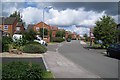
2
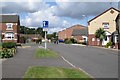
Holyoke Grove, Whitnash
Seen from Erica Drive
Image: © Robin Stott
Taken: 22 Aug 2009
0.07 miles
3
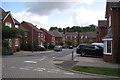
Houses off the south end of Anderson Drive, Whitnash
They look out over the Leamington and County golf course, behind the hedge, left.
Image: © Robin Stott
Taken: 22 Aug 2009
0.08 miles
4
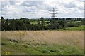
Pylon near Mallory Court, south of Whitnash
High voltage power lines emerge after their undergrounding through Heathcote Image and the Warwick Gates estate. In the distance, to the left, is the nether part of the Leamington and County golf course, as seen from the Harbury Lane greenspace.
Image: © Robin Stott
Taken: 22 Aug 2009
0.08 miles
5
Erica Drive, Whitnash
The turning on the left is Villebon Way.
Image: © Robin Stott
Taken: 22 Aug 2009
0.08 miles
6
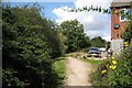
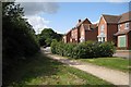
Footpath, rear of Rideswell Grove, Whitnash
The footpath on the west side of the South Farm II estate runs above the main falling sewer (the sewage is then pumped up to wherever). The massive hedgerow, left, grows on a double bank and ditch, marking the Whitnash/Bishop's Tachbrook parish boundary.
Image: © Robin Stott
Taken: 22 Aug 2009
0.10 miles
7
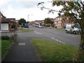
Coppice Road, Whitnash
The south side of the Whitnash circulation system. There are a couple of shops, a pub, and buses to Leamington. The turning on the left is Erica Drive.
Image: © Robin Stott
Taken: 22 Aug 2009
0.11 miles
8
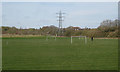
Terminal tower by the recreation ground, Harbury Lane, Whitnash
These high voltage lines are undergrounded through the Warwick Gates estate, emerging here to continue to Harbury. The recreation ground was provided under an associated planning agreement. The western slope, left, and the narrow eastern end have been planted with native trees. Rooftops are of houses on the Anderson Drive development. Two reverse views are Image and Image
Image: © Robin Stott
Taken: 26 Mar 2017
0.14 miles
9
Landor House, Whitnash
Seen from the Harbury Lane greenspace.
Image: © Robin Stott
Taken: 22 Aug 2009
0.16 miles
10
Landor House, Whitnash
Landor Road, which circulates round the west side of Whitnash, here at its south end becomes Coppice Road.
Image: © Robin Stott
Taken: 22 Aug 2009
0.16 miles