IMAGES TAKEN NEAR TO
Court Street, LEAMINGTON SPA, CV31 2BB
Introduction
This page details the photographs taken nearby to Court Street, CV31 2BB by members of the Geograph project.
The Geograph project started in 2005 with the aim of publishing, organising and preserving representative images for every square kilometre of Great Britain, Ireland and the Isle of Man.

There are currently over 7.5m images from over14,400 individuals and you can help contribute to the project by visiting https://www.geograph.org.uk
Image Map
Images are licensed for reuse under creativecommons.org/licenses/by-sa/2.0
Notes
- Clicking on the map will re-center to the selected point.
- The higher the marker number, the further away the image location is from the centre of the postcode.
Image Listing (661 Images Found)
Images are licensed for reuse under creativecommons.org/licenses/by-sa/2.0
Image
Details
Distance
1

Althorpe Street railway bridges
There is an OS benchmark Image on the road face of the abutment of the dismantled bridge on the right hand side of the image
Image: © Roger Templeman
Taken: 3 Sep 2012
0.02 miles
2
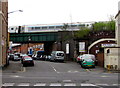
Train on Althorpe Street railway bridge, Royal Leamington Spa
Viewed across the A425 from George Street.
Image: © Jaggery
Taken: 19 Apr 2015
0.02 miles
3

Benchmark on Althorpe Street railway bridge
Ordnance Survey cut mark benchmark described on the Bench Mark Database at http://www.bench-marks.org.uk/bm34468
Image: © Roger Templeman
Taken: 3 Sep 2012
0.03 miles
4
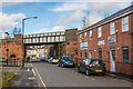
Court Street
Once an area of terraced housing, it was cleared post war and now consists of car parks and small businesses/industrial premises. The building on the right houses a dentist's practice. The bridge carries the railway from Banbury into Leamington Spa station.
Image: © Ian Capper
Taken: 4 Mar 2017
0.03 miles
5
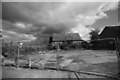
Cloudy future
This former school building is lying derelict in what is now an industrial area of Royal Leamington Spa. In recent times it saw use as a tyre depot but was abandoned some years ago and looks increasingly dilapidated. It's future looks grim. Somehow B&W and the gathering rain clouds seemed appropriate.
Image: © Colin Craig
Taken: 12 Sep 2010
0.03 miles
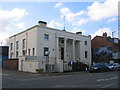
7
The Polish Centre in Royal Leamington Spa
The white and red national flag of Poland flies from a flagstaff on top of the building on the corner
of High Street and Althorpe Street. See http://www.geograph.org.uk/photo/128149 for some details of the building's previous use.
Image: © Jaggery
Taken: 19 Apr 2015
0.04 miles
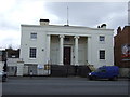
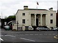
8
Leamington Spa's first town hall
This building on High Street was Leamington's first town hall, dating from 1831 and built to match the town's growth into a fashionable place to visit and take the waters. When the new town hall Image opened in 1884 the local police, who up until then had occupied a small corner of the building, took it over completely and it became Leamington Police Station. The police too have moved to new larger premises in Hamilton Terrace Image and today it is the Polish Club, reflecting the many Poles who came to the town as wartime refugees.
Image: © David Stowell
Taken: 25 Feb 2006
0.04 miles
9
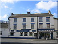
The Hope Tavern
A traditional pub on the corner of Court Street and High Street. The fence above the roof to the left is the edge of the railway viaduct, formerly the LNWR/LMS line to Rugby.
Image: © David Stowell
Taken: 25 Feb 2006
0.04 miles
10
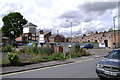
Court Street, car park and pigeon loft
The much-reduced car park is home to a pigeon loft. It is part of a strategy to manage the pigeon population while allowing a section of the community to feed the birds in the practice of their faith.
Image: © Robin Stott
Taken: 24 Jul 2009
0.04 miles